Maps of the canals and rivers of England & Wales.
These are the most up to date and clearest maps of the waterways of England & Wales.
View on your computer, laptop, smart phone, or tablet, or print if you prefer the traditional paper format.
GPS tracking (on devices with GPS) shows you exactly where you are as you move along the map.
Monthly updates ensure you start with an up to date map, with options to keep it up to date too.
Purchasing
The England & Wales Cruising Maps are available to purchase and download in Acrobat (pdf) and Memory‑Map (qct) formats as follows:-
- £49.00 – Acrobat (pdf) format only
- £79.00 – Memory‑Map (qct) format (with free Acrobat (pdf) format).
Clear Maps
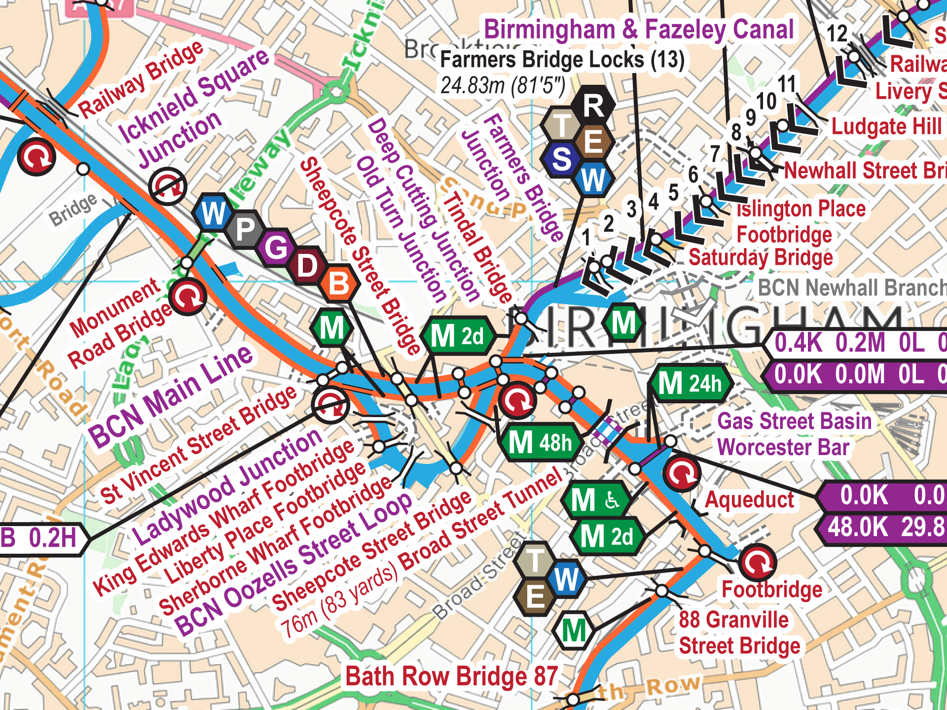
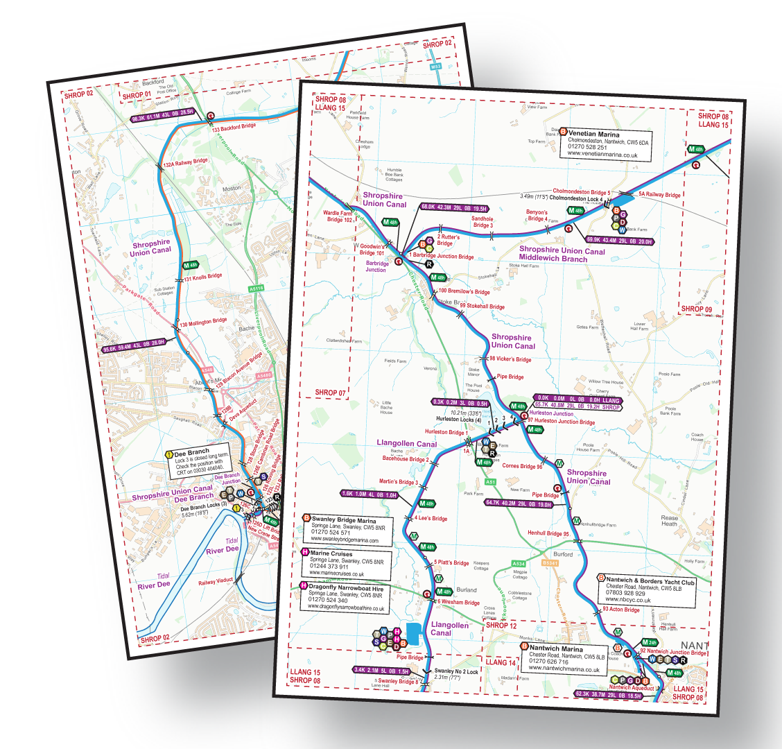
Clear presentation shows the Locks, bridges, and aqueducts etc. superimposed on an Ordnance Survey (OS) background map. Icons represent all the facilities, including moorings and their time limits. Download the key to see the features which appear on the maps.
Information bars, positioned every half hour, show the distance from the end of the canal, in kilometres and miles, the number of locks, the number of opening bridges, and the cruising time in hours.
Routes Covered
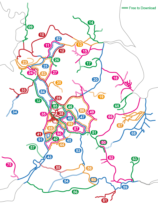
The maps cover the all the routes shown coloured on the map (click to enlarge).
Map Formats
The England & Wales Map is available in a choice of two formats:-
Printout A4 or A5
The Acrobat (pdf) map includes 1,140 pages of maps plus 4 cover pages. These can be viewed on screen a page at a time.
Yes, that’s more than 1,000 pages of maps.
The pages are sized for printing A4, or A5 if your eyesight is good enough.
This map can be used on computers, laptops, phones and tablets with Acrobat Reader (or equivalent) software or app installed.
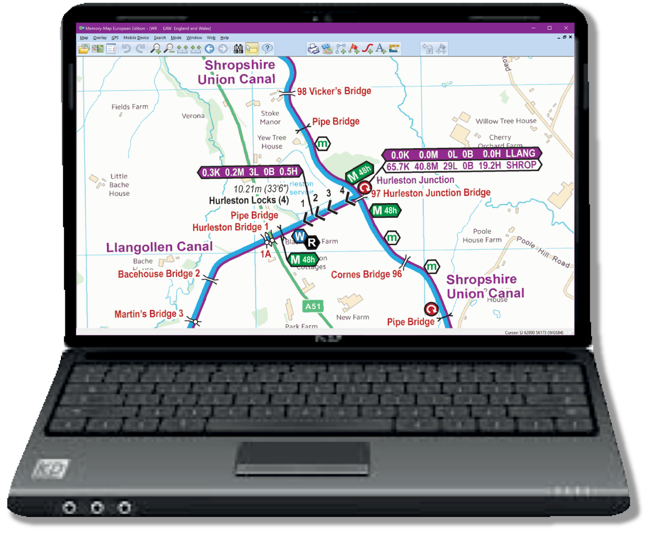
Laptop or Computer
The Memory-Map (qct) map has the same map pages joined into one scrollable and zoomable map.
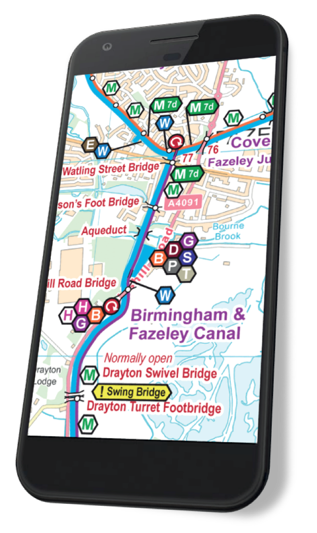
This map works on Android, iPhone/iPad, Windows and Mac with Memory‑Map (or equivalent) software or app installed, and the classic map compatibility option enabled.
Delivery
The England & Wales maps are so detailed they are a very large download, totalling over 2GB.
The maps are also available on a data DVD by post.
Free Map Examples
My maps for the Droitwich Canals are free to download in both Acrobat (pdf) and Memory‑Map (qct) formats. Please download and try these to see how good my maps are, and make sure you can install them on your device(s).
I also produce maps for canal restoration projects which are all free to download in both Acrobat (pdf) and Memory‑Map (qct) formats. These restoration maps are very similar in style to the maps for the open waterways.
Licencing and Copyright
The licence conditions permit you to use my maps on up to five devices. That’s computers, laptops, phones, tablets etc.
The maps are licenced for personal use. Business licences are available on request.
Copyright in the background maps is held by Ordnance Survey. Copyright in all other work is held by Waterway Routes. The maps should not be copied without permission except for the limited circumstances permitted by law.
DVDs
I also produce a great range of DVDs in a choice of formats:-
- Popular – Like a television programme with highlights of a cruise, including commentary and background music.
- Bowcam – A forward facing camera, running all the time, then speeded up to show the whole route.
- Combined – Both Popular and Bowcam DVDs in one box
Alternatives
You can purchase maps for each waterway separately if you prefer. The England & Wales map will often be better value and is much cheaper than buying a set of individual maps.
Upgrading
You can upgrade to the England & Wales map at a discounted price if you have already purchased one (or more) individual map(s).
Purchasing
The England & Wales Cruising Maps are available to purchase and download in Acrobat (pdf) and Memory‑Map (qct) formats as follows:-
 RSS Blog Feed
Is the full map a single pdf and a single qct or all of the individual ones? I’m thinking of the space on my phone and it would be better to load just the qct for the waterway that I’m on rather than the whole system.
It is better to put the whole country map onto your phone. If you are using Memory-Map then you only need the qct version if you are short of space.
I stopped supplying the individual maps a long time ago so you must have a very out of date version of my maps if you are thinking of using them. Think of all those monthly updates you must be missing. See http://www.waterwayroutes.co.uk/updates for how to update to the latest version at a discounted price.
Hi if I buy the full map will I get the updates free or is there a subscription charge for future updates?
Lyndon: The arrangements for map updates are shown on my Map Updates page. Paul.
Hi if i was to download Memory Map to My iMac will I be able to also Load view / Share on my iPad & iPhone will it be useable on all three devices?
or will I have to pay for each download ie pay three times
Amie : My licence condition for the map allow it to be used on any five devices. That’s computers, laptops, phones, tablets etc.
You will need to check with Memory-Map about the licensing for their Software and App which will need the “Classic Map Compatability” option enabled to open my maps.
Please use my free maps to make sure you can conquer Memory-Map’s installation process which is a little tricky, especially on Apple products.
Thank you for your interest in my maps. Paul.
Thomas: Thank you for your interest in my maps.
Yes, you can purchase maps of just the
Caldon Canal. These are the most up to date and detailed maps available and they are updated monthly. That’s why they are only available to download as it would be impossible to re-print hard copies on a monthly basis.
The Caldon Canal Map is available as an Acrobat (pdf) file and you can just print the page(s) you wish for a hard copy.
That way you get an up to date map, which is cheaper than buying a printed book of maps which are likely to be out of date, and more environmentally friendly too.
If you are struggling with the concept of downloading and printing an Acrobat (pdf) file then perhaps you have a friend or family member who can help, or do it for you.
This link will take you straight to the
Caldon Canal Map.
Is it possible to purchase a hard copy of a detailed map just of the Caldon Canal which I plan to visit later this year ? The download options are way beyond my computer understanding, and probably include a wide range of other maps I do not need.