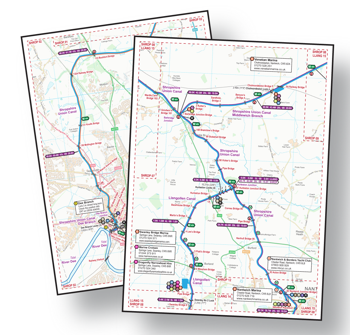
I am pleased to announce the December release of my maps includes Manchester Bolton & Bury Canal Maps and, like all my maps for restoration projects, these are FREE to download. The canal once ran from Salford (not Manchester!) to Continue reading Manchester Bolton & Bury Canal Maps→
I’m pleased to announce the latest release in my series of free maps supporting waterway restoration projects. The Melton Mowbray Navigation runs from the junction with the Grand Union Canal’s Leicester Section at Syston, just North of Leicester, to Melton Continue reading Melton Mowbray Navigation and Oakham Canal – FREE Maps→
I’m pleased to announce the release of the next in my series of free canal maps for restoration projects. This covers the Wey & Arun Canal, the River Arun, the River Rother, and the Portsmouth & Arundel Canal, all in one map. Continue reading Wey & Arun Canal – FREE Maps→
The Wisbech Canal once ran between the tidal River Nene at Wisbech and Well Creek at Outwell on the Middle Level Navigations. It was closed in 1926. I have added the Wisbech Canal to the range of free canal maps Continue reading Wisbech Canal Maps→
I am pleased to say our River Nene DVDs have just been released. The River Nene DVDs are available in our usual three formats:- Popular – like a television programme showing the highlights of the canal Bowcam – a forward Continue reading River Nene DVDs→
We have three Maps and three DVDs covering the waterways of the Fens. These are now available in sets of three at discounted prices. They are still available individually as River Nene – Maps or DVDs Middle Level Navigations – Continue reading Sets of 3 Maps or 3 DVDs→
I have recently added a map for The Wash. Please note this is for general information only and should not be used for navigation. You should use full charts, an experienced pilot or guide, or have your own local knowledge. Continue reading The Wash Maps→
It’s the middle of the month and the latest map updates have just been published. Our England & Wales map is now at Issue 42 with the monthly updates – nobody else can match that for regular updating. We’ve collected Continue reading Map Updates – September 2015 – Issue 42→
I’ve just published the October 2015 updates for our maps of canals and rivers. Our England & Wales map is now at Issue 43 with the monthly updates. These include the changes we have identified ourselves by cruising along the Continue reading Map Updates – October 2015 – Issue 43→
I’ve just published the monthly update to my maps for November 2015 and the England & Wales map is now as Issue 44. Many of the changes are small, but important to those involved. One example is completion of the Continue reading Map Updates – November 2015 – Issue 44→
I’ve just released the December batch of map updates, bringing them up to issue 45. Over forty maps have been updated, although many of the changes are very minor but I like to keep them up to date. Even a Continue reading Map Updates – December 2015 – Issue 45→
The January 2016 monthly updates for my maps are now available on my website. You can see a full list of the issued maps and those with significant changes are: England & Wales Canal Map Bridgewater Canal Map Manchester Ship Continue reading Map Updates – January 2016 – Issue 46→
The February 2016 monthly updates for my maps are now available on my website. You can see a full list of the issued maps and those with significant changes are: England & Wales Canal Map Ashton and Peak Forest Canal Map Continue reading Map Updates – February 2016 – Issue 47→
I’m pleased to announce the March 2016 updates to my cruising maps are now available. You can see a full list of the latest issue of the maps, but those with significant changes this month are:- England & Wales Canal Continue reading Map Updates – March 2016 – Issue 48→
I’m pleased to announce the April 2016 updates to my cruising maps are now available. You can see a full list of the latest issue of the maps, but those with significant changes this month are:- England & Wales Canal Map Continue reading Map Updates – April 2016 – Issue 49→
I’m pleased to announce the May 2016 updates to my cruising maps are now available. All of the maps have been updated this month, to include the latest Ordnance Survey (OS) background maps. Most have updates to the waterway features too. I Continue reading Map Updates – May 2016 – Issue 50→
I’m pleased to announce the June 2016 updates to my cruising maps are now available. You can see a full list of the latest issue of the maps, but those with significant changes this month are:- England & Wales Canal Map Continue reading Map Updates – June 2016 – Issue 51→
I’m pleased to announce the July 2016 updates to my cruising maps are now available. You can see a full list of the latest issue of the maps, but those with significant changes this month are:- England & Wales Canal Map Continue reading Map Updates – July 2016 – Issue 52→
I’m pleased to announce the August 2016 updates to my cruising maps are now available. You can see a full list of the latest issue of the maps, but those with significant changes this month are:- England & Wales Canal Continue reading Map Updates – August 2016 – Issue 53→
I’m pleased to announce the September 2016 updates to my cruising maps are now available. You can see a full list of the latest issue of the maps, but those with significant changes this month are:- England & Wales Canal Continue reading Map Updates – September 2016 – Issue 54→
I’m pleased to announce the October 2016 updates to my cruising maps are now available. You can see a full list of the latest issue of the maps, but those with significant changes this month are:- England & Wales Canal Continue reading Map Updates – October 2016 – Issue 55→
I’m pleased to announce the November 2016 updates to my cruising maps are now available. You can see a full list of the latest issue of the maps, but those with significant changes this month are:- England & Wales Canal Continue reading Map Updates – November 2016 – Issue 56→
I’m pleased to announce the December 2016 updates to my cruising maps are now available. You can see a full list of the latest issue of the maps, but those with significant changes this month are:- England & Wales Canal Continue reading Map Updates – December 2016 – Issue 57→
I’m pleased to announce the January 2017 updates to my cruising maps are now available. I’ve imported new OS background maps this month, so all the maps have been re-issued. A few have no other changes but most have some Continue reading Map Updates – January 2017 – Issue 58→
I’m pleased to announce the February 2017 updates to my cruising maps are now available. Many of the maps have changes this month – those with significant changes are:- England & Wales Canal Map Daventry Canal Grand Union Canal Huddersfield Canals Continue reading Map Updates – Issue 59 – February 2017→
Yes, I do mean Issue 60. That’s more map updates than you’ll get from anywhere else. I’m pleased to announce the March 2017 updates to my cruising maps are now available. Many of the maps have changes this month – those Continue reading Map Updates – Issue 60 – March 2017→
I’m pleased to announce the April 2017 updates to my cruising maps are now available. As usual, many of the maps have changes this month – those with significant changes are:- England & Wales Waterway Map Black Country Ring Canal Continue reading Map Updates – Issue 61 – April 2017→
I’m pleased to announce the May 2017 updates to my cruising maps are now available. As usual, many of the maps have changes this month – those with significant changes are:- England & Wales Waterway Map East Midlands (Leicester) Ring Continue reading Map Updates – Issue 62 – May 2017→
I’m pleased to announce the June 2017 updates to my cruising maps are now available. As usual, many of the maps have changes this month – those with the most significant changes are:- England & Wales Waterway Map Avon Ring Continue reading Map Updates – Issue 63 – June 2017→
I’m pleased to announce the July 2017 updates to my cruising maps are now available. As usual, many of the maps have changes this month – those with the most significant changes are:- England & Wales Waterway Map Avon Ring Map Continue reading Map Updates – Issue 64 – July 2017→
I’m pleased to announce the August 2017 updates to my cruising maps are now available. As usual, many of the maps have minor changes this month – those with the most significant changes are:- England & Wales Waterway Map Birmingham Continue reading Map Updates – Issue 65 – August 2017→
I’m pleased to announce the September 2017 updates to my cruising maps are now available. As usual, many of the maps have minor changes this month – those with the most significant changes are:- England & Wales Waterway Map Black Continue reading Map Updates – Issue 66 – September 2017→
I’m pleased to announce the October 2017 updates to my cruising maps are now available. As usual, many of the maps have minor changes this month – those with the most significant changes are:- England & Wales Waterway Map Black Continue reading Map Updates – Issue 67 – October 2017→
I’m pleased to announce the November 2017 updates to my cruising maps are now available. As usual, many of the maps have minor changes this month – those with the most significant changes are:- England & Wales Waterway Map Avon Continue reading Map Updates – Issue 68 – November 2017→
I’m pleased to announce the December 2017 updates to my cruising maps are now available. As usual, many of the maps have minor changes this month – those with the most significant changes are:- England & Wales Canal Map Cheshire Continue reading Map Updates – Issue 70 – December 2017→
I am pleased to say monthly updates for my maps for November 2018 are now available. All these monthly updates mean you not only start with an up to date map but you can keep them up to date too. Continue reading Map Updates – Issue 82 – November 2018→
I am pleased to say monthly updates for my maps for December 2018 are now available. All these monthly updates mean you not only start with an up to date map but you can keep them up to date too. The Continue reading Map Updates – Issue 83 – December 2018→
Download maps of the Bridgewater Canal. The most up to date and clearest maps of the Bridgewater Canal are available for download. View on your computer, laptop, smart phone, or tablet, or print if you prefer the traditional paper format. Continue reading Bridgewater Canal Maps→
Free Maps These are my free maps covering the Montgomery Canal. Download these free maps (from the links at the end) to see how good my maps are, and to check you can install them on your device(s). All the Continue reading Montgomery Canal Maps – FREE→
I am pleased to say monthly updates for my maps for January 2019 are now available. All these monthly updates mean you not only start with an up to date map but you can keep them up to date too. The Continue reading Map Updates – Issue 84 – January 2019→
I am pleased to say the monthly updates for my maps for December 2019 are now available. All these monthly updates mean you not only start with an up to date map but you can keep them up to date Continue reading Map Updates – Issue 95 – December 2019→
Download maps of the Macclesfield Canal. The most up to date and clearest maps of the Macclesfield Canal are available for download. View on your computer, laptop, smart phone, or tablet, or print if you prefer the traditional paper format. Continue reading Macclesfield Canal Maps→
Download maps of the Bridgwater & Taunton and Grand Western Canals. The most up to date and clearest maps of the Bridgwater & Taunton and Grand Western Canals are available for download. View on your computer, laptop, smart phone, or Continue reading Bridgwater & Taunton and Grand Western Canals Maps→
I am pleased to say the monthly updates for my maps for May 2019 are now available. All these monthly updates mean you not only start with an up to date map but you can keep them up to date Continue reading Map Updates – Issue 88 – May 2019→
I am pleased to say the monthly updates for my maps for April 2019 are now available. All these monthly updates mean you not only start with an up to date map but you can keep them up to date Continue reading Map Updates – Issue 87 – April 2019→
I am pleased to say the monthly updates for my maps for March 2019 are now available. All these monthly updates mean you not only start with an up to date map but you can keep them up to date Continue reading Map Updates – Issue 86 – March 2019→
I am pleased to say monthly updates for my maps for February 2019 are now available. All these monthly updates mean you not only start with an up to date map but you can keep them up to date too. Continue reading Map Updates – Issue 85 – February 2019→
Yes, this really is the 80th monthly update for my maps. All these monthly updates mean you not only start with an up to date map but you can keep them up to date too. There are many maps with updates Continue reading Map Updates – Issue 80 – October 2018→
I’m pleased to announce the September 2018 updates to my cruising maps are now available. There are many maps with updates, with these maps having the most significant changes:- England & Wales Waterway Map Avon Ring Birmingham Mini Ring Black Country Continue reading Map Updates – Issue 79 – September 2018→
I’m pleased to announce the August 2018 updates to my cruising maps are now available. Once again there are many maps with updates. These maps have the most significant updates:- England & Wales Canal Map Cheshire Ring Map East Midlands Continue reading Map Updates – Issue 78 – August 2018→
I’m pleased to announce the July 2018 updates to my cruising maps are now available. There are lots of updates this month, and those maps with the most significant updates are:- England & Wales Canal Map Avon Ring Black Country Continue reading Map Updates – Issue 77 – July 2018→
I’m pleased to announce the June 2018 updates to my cruising maps are now available. Having been busy with the Crick Boat Show there aren’t as many updates this month as normal. There are many maps with very minor changes Continue reading Map Updates – Issue 76 – June 2018→
I’m pleased to announce the May 2018 updates to my cruising maps are now available. As usual, many of the maps have changes this month – those with the most changes are:- England & Wales Canal Map Avon Ring Map Black Continue reading Map Updates – Issue 75 – May 2018→
I’m pleased to announce the April 2018 updates to my cruising maps are now available. As usual, many of the maps have changes this month – those with the most significant changes are:- England & Wales Canal Map Cheshire Ring Continue reading Map Updates – Issue 74 – April 2018→
I’m pleased to announce the March 2018 updates to my cruising maps are now available. As usual, many of the maps have changes this month – those with the most significant changes are:- England & Wales Canal Map Four Counties Continue reading Map Updates – Issue 73 – March 2018→
I’m pleased to announce the February 2018 updates to my cruising maps are now available. As usual, many of the maps have minor changes this month – those with the most significant changes are:- England & Wales Canal Map Cotswold Continue reading Map Updates – Issue 72 – February 2018→
I’m pleased to announce the January 2018 updates to my cruising maps are now available. As usual, many of the maps have minor changes this month – those with the most significant changes are:- England & Wales Canal Map Cheshire Continue reading Map Updates – Issue 71 – January 2018→
Download maps of the Aire & Calder and Calder & Hebble Navigations. The most up to date and clearest maps of the Aire & Calder and Calder & Hebble Navigations are available for download. View on your computer, laptop, smart Continue reading Aire & Calder and Calder & Hebble Navigations Maps→
Download maps of the Ashby Canal. The most up to date and clearest maps of the Ashby Canal are available for download. View on your computer, laptop, smart phone, or tablet, or print if you prefer the traditional paper format. Continue reading Ashby Canal Maps→
Free Maps These are my free maps covering the Ashby Canal (Restoration Section) Download these free maps (from the links at the end) to see how good my maps are, and to check you can install them on your device(s). Continue reading Ashby Canal (Restoration) Maps – FREE→
Download maps of the Ashton and Peak Forest Canals. The most up to date and clearest maps of the Ashton and Peak Forest Canals are available for download. View on your computer, laptop, smart phone, or tablet, or print if Continue reading Ashton and Peak Forest Canals Maps→
Download maps of the Avon Ring. The most up to date and clearest maps of the Avon Ring are available for download. View on your computer, laptop, smart phone, or tablet, or print if you prefer the traditional paper format. Continue reading Avon Ring Maps→
Download maps of the River Avon (Stratford). The most up to date and clearest maps of the River Avon (Stratford) are available for download. View on your computer, laptop, smart phone, or tablet, or print if you prefer the traditional Continue reading River Avon (Stratford) Maps→
Free Maps These are my free maps covering the Higher Avon (Proposed). Download these free maps (from the links at the end) to see how good my maps are, and to check you can install them on your device(s). All Continue reading Higher Avon (Proposed) Maps→
Download maps of the Birmingham & Fazeley Canal. The most up to date and clearest maps of the Birmingham & Fazeley Canal are available for download. View on your computer, laptop, smart phone, or tablet, or print if you prefer Continue reading Birmingham & Fazeley Canal Maps→
Download maps of the River Wey and Basingstoke Canal. The most up to date and clearest maps of the River Wey and Basingstoke Canal are available for download. View on your computer, laptop, smart phone, or tablet, or print if Continue reading River Wey and Basingstoke Canal Maps→
Download maps of the Birmingham Canal Navigations (BCN). The most up to date and clearest maps of the Birmingham Canal Navigations (BCN) are available for download. View on your computer, laptop, smart phone, or tablet, or print if you prefer Continue reading Birmingham Canal Navigations (BCN) Maps→
We start from Gas Street Basin and Worcester Bar in the centre of Birmingham and pass Old Turn Junction to see the loops of Brindley’s Old Main Line and the more direct route of Telford’s New Main Line. We progress Continue reading Birmingham Canal Navigations (BCN) DVDs→
Free Maps These are my free maps covering the Bradley Canal. Download these free maps (from the links at the end) to see how good my maps are, and to check you can install them on your device(s). All the Continue reading Bradley Canal (Restoration) Maps – FREE→
Download maps of the Birmingham Mini Ring. The most up to date and clearest maps of the Birmingham Mini Ring are available for download. View on your computer, laptop, smart phone, or tablet, or print if you prefer the traditional Continue reading Birmingham Mini Ring Maps→
Download maps of the Black Country Ring. The most up to date and clearest maps of the Black Country Ring are available for download. View on your computer, laptop, smart phone, or tablet, or print if you prefer the traditional Continue reading Black Country Ring Maps→
The Bradford Canal once ran from the Leeds & Liverpool Canal at Shipley to Bradford. It opened in 1774 and closed in 1922. There are proposals to re-open it. I have added the Bradford Canal to the range of free Continue reading Bradford Canal→
Free Maps These are my free maps covering the Bradford Canal. Download these free maps (from the links at the end) to see how good my maps are, and to check you can install them on your device(s). All the Continue reading Bradford Canal Maps – FREE→
Free Maps These are my free maps covering the Buckingham Canal. Download these free maps (from the links at the end) to see how good my maps are, and to check you can install them on your device(s). All the Continue reading Buckingham Canal (Restoration) Maps – FREE→
Download maps of the Caldon Canal. The most up to date and clearest maps of the Caldon Canal are available for download. View on your computer, laptop, smart phone, or tablet, or print if you prefer the traditional paper format. Continue reading Caldon Canal Map→
Download maps of the Cheshire Ring. The most up to date and clearest maps of the Cheshire Ring are available for download. View on your computer, laptop, smart phone, or tablet, or print if you prefer the traditional paper format. Continue reading Cheshire Ring Maps→
Download maps of the Chesterfield Canal. The most up to date and clearest maps of the Chesterfield Canal are available for download. View on your computer, laptop, smart phone, or tablet, or print if you prefer the traditional paper format. Continue reading Chesterfield Canal Maps→
Free Maps These are my free maps covering the Chesterfield Canal (Restoration Section) Download these free maps (from the links at the end) to see how good my maps are, and to check you can install them on your device(s). Continue reading Chesterfield Canal (Restoration) Maps – FREE→
Free Maps These are my free maps covering the Cotswold Canals. Download these free maps (from the links at the end) to see how good my maps are, and to check you can install them on your device(s). All the Continue reading Cotswold Canals (Restoration) Maps – FREE→
Download maps of the Coventry Canal. The most up to date and clearest maps of the Coventry Canal are available for download. View on your computer, laptop, smart phone, or tablet, or print if you prefer the traditional paper format. Continue reading Coventry Canal Maps→
Free Maps These are my free maps covering the Daventry Canal (Proposed). Download these free maps (from the links at the end) to see how good my maps are, and to check you can install them on your device(s). All Continue reading Daventry Canal (Proposed) Maps→
Free Maps These are my free maps covering the River Dee. Download these free maps (from the links at the end) to see how good my maps are, and to check you can install them on your device(s). All the Continue reading River Dee Maps – FREE→
Free Maps These are my free maps of the Droitwich Canals. Download these free maps (from the links at the end) to see how good my maps are, and to check you can install them on your device(s). All the Continue reading Droitwich Canals Maps – FREE→
Download maps of the East Midlands (Leicester) Ring. The most up to date and clearest maps of the East Midlands (Leicester) Ring are available for download. View on your computer, laptop, smart phone, or tablet, or print if you prefer Continue reading East Midlands (Leicester) Ring Maps→
Maps of the canals and rivers of England & Wales. These are the most up to date and clearest maps of the waterways of England & Wales. View on your computer, laptop, smart phone, or tablet, or print if you Continue reading England & Wales Waterway Maps→
Download maps of the Forth & Clyde and Union Canals. The most up to date and clearest maps of the Forth & Clyde and Union Canals are available for download. View on your computer, laptop, smart phone, or tablet, or Continue reading Forth & Clyde and Union Canals Maps→
Download maps of the Fossdyke & Witham Navigation and Tributaries. The most up to date and clearest maps of the Fossdyke & Witham Navigation and Tributaries are available for download. View on your computer, laptop, smart phone, or tablet, or Continue reading Fossdyke & Witham Navigation and Tributaries Maps→
Download maps of the Four Counties Ring. The most up to date and clearest maps of the Four Counties Ring are available for download. View on your computer, laptop, smart phone, or tablet, or print if you prefer the traditional Continue reading Four Counties Ring Maps→
Free Maps These are my free maps covering the Rivers Glen, Welland and Fens Link. Download these free maps (from the links at the end) to see how good my maps are, and to check you can install them on Continue reading Rivers Glen, Welland and Fens Link Maps→
Download maps of the River Great Ouse and Tributaries. The most up to date and clearest maps of the River Great Ouse and Tributaries are available for download. View on your computer, laptop, smart phone, or tablet, or print if Continue reading River Great Ouse and Tributaries Maps→
Joining the River Great Ouse through Salters Lode Lock on the Middle Level Navigations we’ll show the tidal crossing to Denver Lock, then follow the river upstream to the limit of navigation at Bedford. We’ll visit each of the connected Continue reading River Great Ouse and Tributaries DVDs→
Free Maps These are my free maps covering the Grantham Canal. Download these free maps (from the links at the end) to see how good my maps are, and to check you can install them on your device(s). All the Continue reading Grantham Canal (Restoration) Maps – FREE→
Free Maps These are my free maps covering Sir Nigel Gresley’s Canal. Download these free maps (from the links at the end) to see how good my maps are, and to check you can install them on your device(s). All Continue reading Sir Nigel Gresley’s Canal Maps – FREE→
Download maps of the Grand Union Canal (North). The most up to date and clearest maps of the Grand Union Canal (North) are available for download. View on your computer, laptop, smart phone, or tablet, or print if you prefer Continue reading Grand Union Canal (All) Maps→