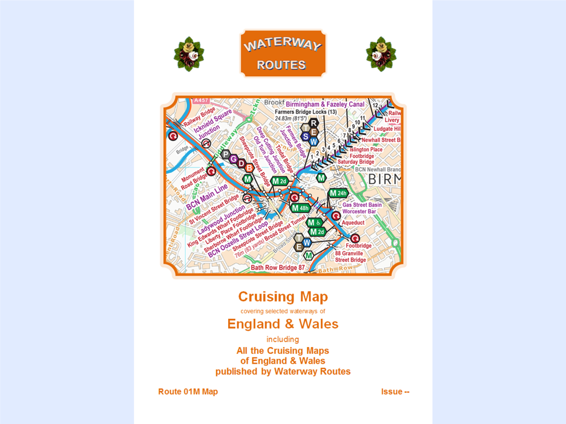
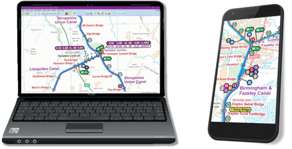
Description
These maps work on Windows, Android, iPhone/iPad and Mac devices providing they have the appropriate App/Software installed.
The licence conditions permit you to use the map on up to five devices (computers, laptops, phones, tablets etc) for personal use. Business licences are available on request.
Shortly after making payment you will receive the download link on screen and by email. Please check your junk mail folders if the email doesn’t appear promptly as your spam filter may have mistaken the download link for spam.
The download link will be valid for 6 months. You may use the link in the email to download any (or all) of the quarterly updates issued during that time to ensure you have the latest version of the map. You can update your map at a discounted price after that.
Please use the free examples to see how good my maps are and check you can conquer the download and installation process before ordering.
Route

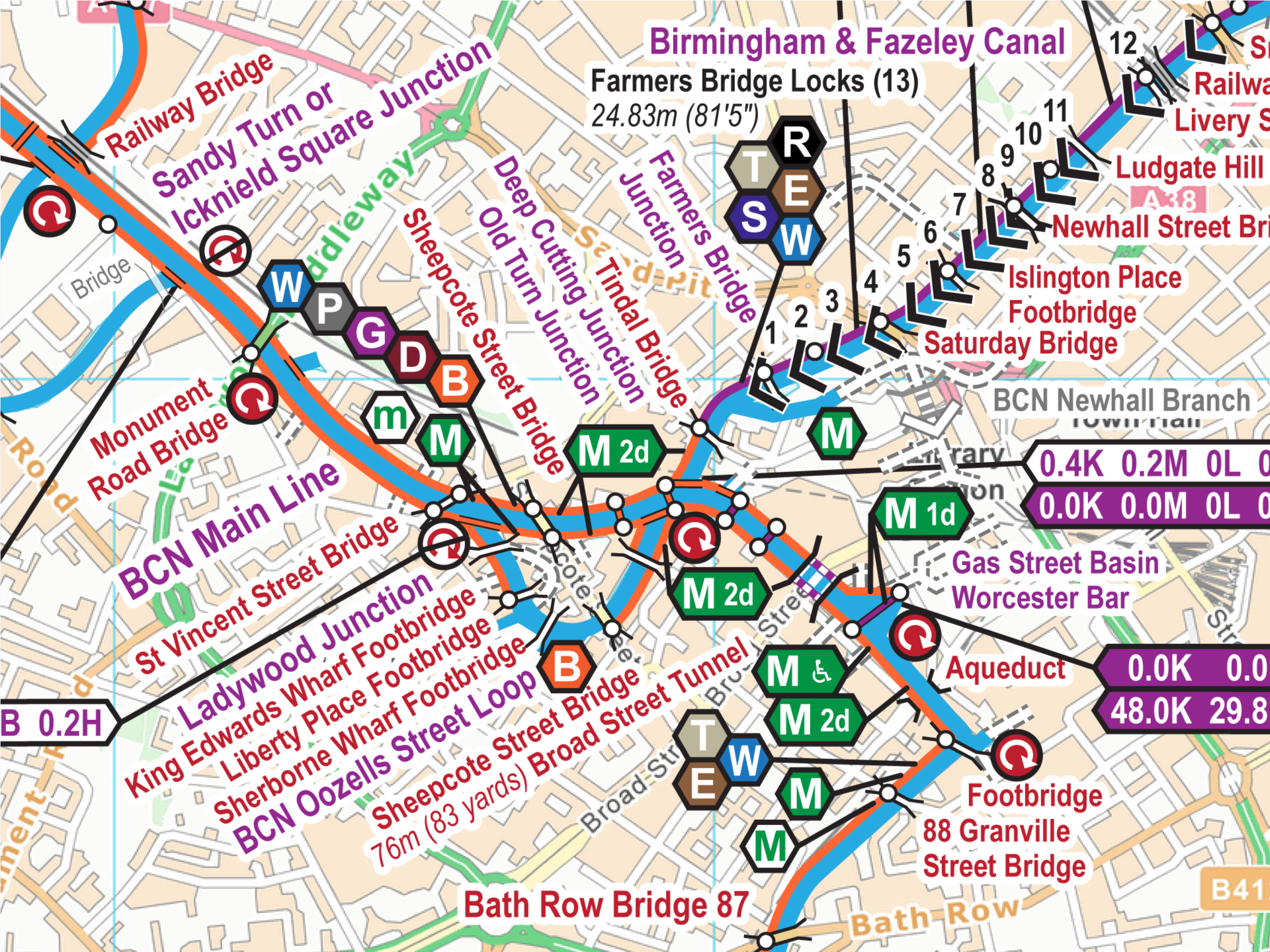
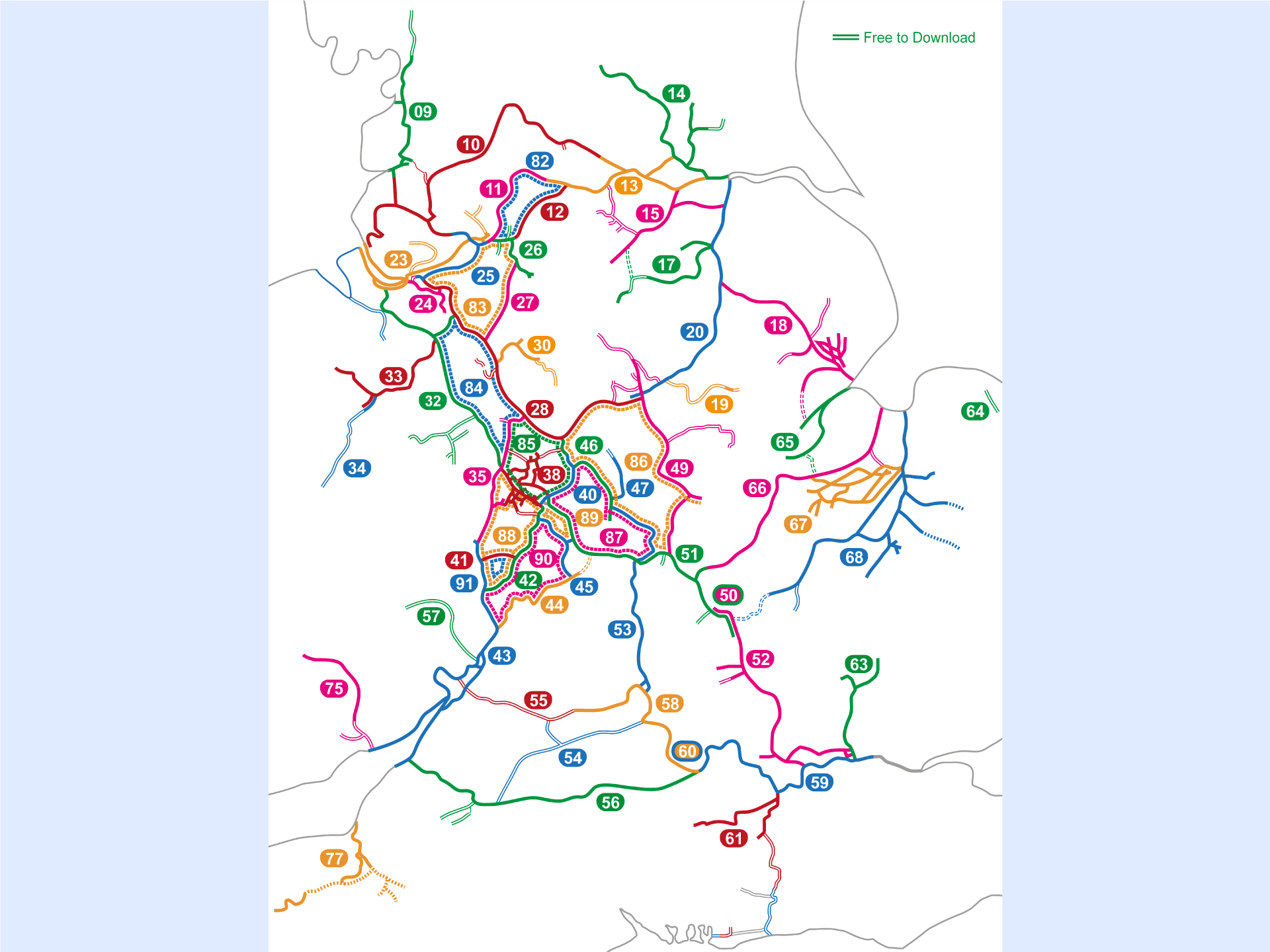
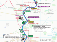
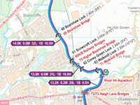
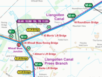
This England & Wales map includes all the waterways shown coloured on this map, including:-
- 09 Lancaster Canal
- 10 Leeds & Liverpool Canal
- 11 Rochdale Canal
- 12 Huddersfield Canals
- 13 Aire & Calder and Calder & Hebble Navigations
- 14 River Ouse and Tributaries
- 15 Sheffield & South Yorkshire Navigations
- 17 Chesterfield Canal
- 18 Fossdyke & Witham Navigation and Tributaries
- 20 River Trent
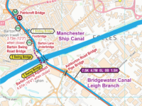
- 23 Manchester Ship Canal
- 24 River Weaver
- 25 Bridgewater Canal
- 26 Ashton and Peak Forest Canals
- 27 Macclesfield Canal
- 28 Trent & Mersey Canal
- 30 Caldon Canal
- 32 Shropshire Union Canal
- 33 Llangollen Canal
- 35 Staffs & Worcester Canal
- 38 Birmingham Canal Navigations (BCN)
- 40 Birmingham & Fazeley Canal
- 42 Worcester & Birmingham Canal
- 43 River Severn and Gloucester & Sharpness Canal
- 44 River Avon (Stratford)
- 45 Stratford upon Avon Canal
- 46 Coventry Canal
- 47 Ashby Canal
- 50 Grand Union Canal
- 53 Oxford Canal
- 56 Kennet & Avon Canal
- 60 River Thames
- 61 River Wey and Basingstoke Canal
- 63 Lee & Stort Navigations
- 66 River Nene
- 67 Middle Level Navigations
- 68 River Great Ouse and Tributaries
- 75 Monmouth & Brecon Canal
- 77 Bridgwater & Taunton and Grand Western Canals
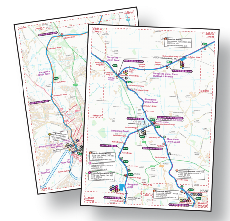
Acrobat (pdf)
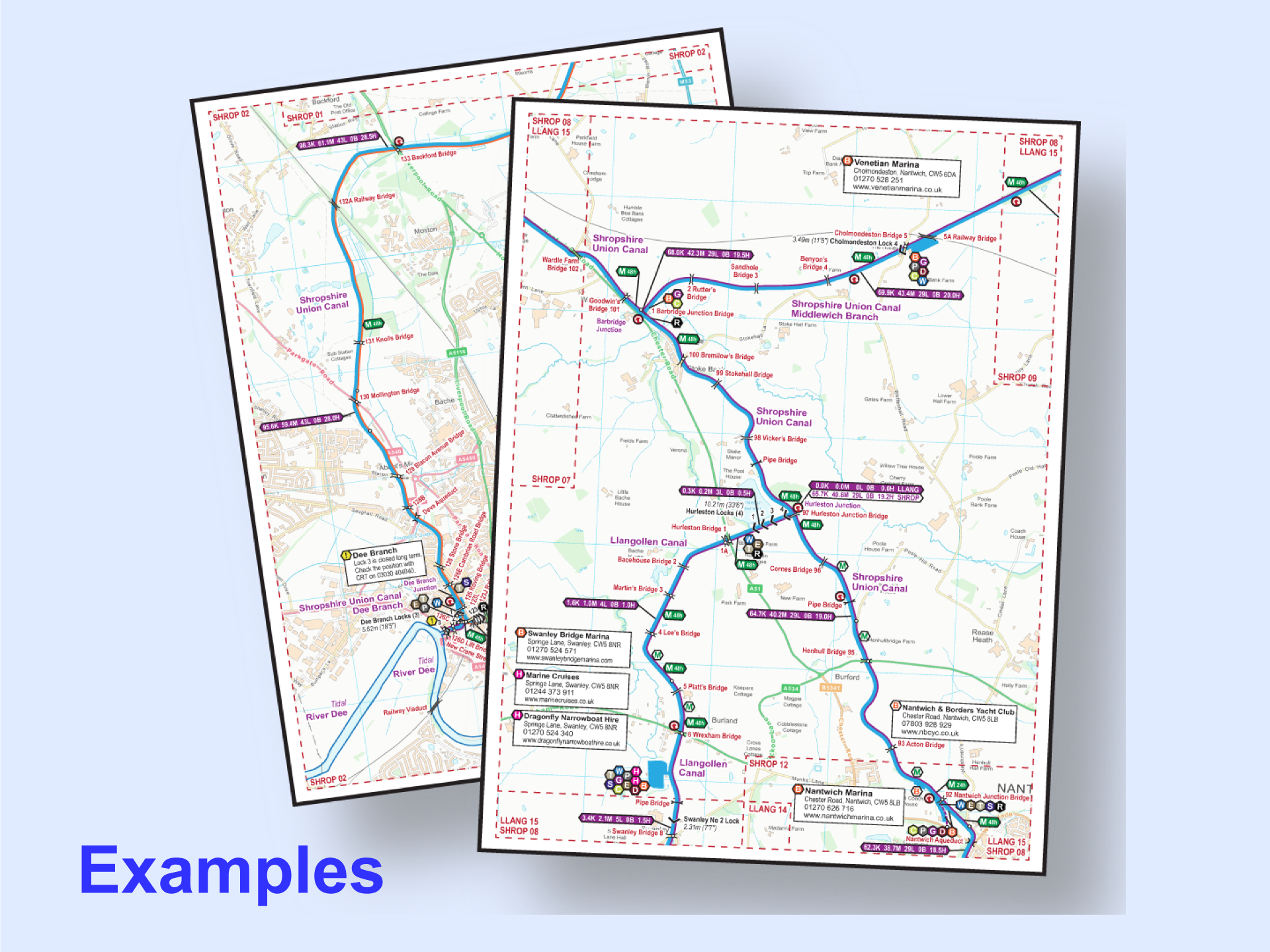
Example pages from my range of maps.
You must have Acrobat Reader (or equivalent) App/Software installed to use my maps in Acrobat (pdf) Format.
Acrobat (pdf) Format maps are split into A4 pages. They can viewed a page at a time on screen, or printed on your own printer. They are designed to be printed A4 size and, if your eyesight is good enough, they can be printed A5. They can be printed A3 if you need a larger print size.
You can read more about using my maps in Acrobat (pdf) Format.
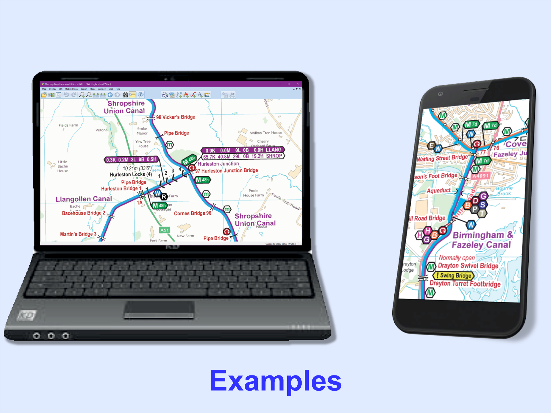
Memory-Map (qct)
Examples from my range of maps.
You must have the Memory-Map App/Software installed to use my maps in Memory-Map (qct) Format. That App/Software must have the Classic Map Compatibility licence enabled and you will have to pay Memory-Map (the company) for that.
Please use the free examples to check Memory-Map’s pricing (after using their initial free trial period) and ensure you can conquer Memory-Map’s tricky installation process (which is especially difficult on Apple products) before ordering.
The maps will track in real time on GPS enabled devices so you know exactly where you are. You can save tracks, routes and waypoints with the Memory-Map software.
You can scroll around the whole map and zoom in and out as required.
You can read more about using my maps in Memory-Map (qct) Format.
Support
You can download the key separately if required. It is included as the last page on every Acrobat (pdf) map and shown at intervals on the Memory-Map (qct) Maps.
You can read more about using my maps on each type of device. These pages are intended to provide general information only and may not be up to date for the latest versions of the App/Software. You will need to follow the instructions from the supplier of the App/Software you are using and seek help from them if you are having problems with their App/Software.
Please note that I only supply the map and I will offer help in the unlikely event of any problems with my map. If you are having problems using an App/Software then you must seek help from the supplier of that App/Software. Please use my free maps to check you can conquer the download and installation process (which is particularly tricky on Apple devices) before purchasing any of my maps.


 RSS Blog Feed
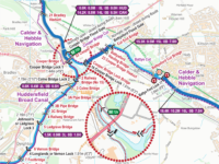
John DiDonato –
Love these maps! My biggest problem is that I have so much fun looking at them that my wife feels left out 🙂
Seriously though, they are extraordinarily helpful and add serenity to every trip I take. I also like that, since they’re in PDF format, I can make my own notes on the map before a trip to highlight any pubs or food shopping spots that I want to look for.
John Charnock (verified owner) –
I first purchased individual maps from Waterway Routes 15 months ago.
I upgraded to the Full England & Wales Map in April last year, and received a substantial discount for doing so.
I have just updated my subscription yesterday.
These maps are some of the most detailed maps on the market. But what set these maps apart from the rest is the GPS location feature. When cruising and using the App on my Sony Xperia phone it shows a GPS accuracy of 8 feet. I find this especially useful when looking for moorings. Coupled with the ability to Track your days cruising, displaying speed, distance, total time and cruising time.
These maps are worth every penny, and I would recommend to anyone.
Plus the customer service from Paul is excellent (10/10)
Stephen Carter (verified owner) –
I have been using Waterways Routes for more years than I care to remember. I find that the amount of accurate information far outweighs any other canal mapping software and would recommend it highly. Together with Memory Map for All it also provides a platform to record the journeys made in real-time, giving an accurate log for archiving.
Graham (verified owner) –
I have used this map selection for 4 years and covered about 85% of the canal system in that time. The map is accurate, up to date and provides excellent detail of the canal and the areas through which you pass and stop at. With this map you do not need any other geographical product to travel round and explore the UK’s water ways. The update facility is an added bonus that helps to ensure every detail is correct.
Arthur Seymour (verified owner) –
This is without doubt the best waterway maps I have come across in 40 years of cruising, I thoroughly recommend it.
David (verified owner) –
The best maps for travelling on the inland waterways. Whilst cruising they show everything you would want to know, including places where you can leave the tow path. The mileage/time/lock boxes make for easy planning by being able to estimate journey times.
Whilst travelling, I print and laminate the maps. I can scribble notes onto them and should they get damaged or lost, just print another set.
For planning, I tend to use the QCT version and Memory-Map.
Ken Deveson (verified owner) –
Absolutely EXCELLENT. Travelled most of the canal and river systems for many, many years using Paul’s Waterways routes for England and Wales. Makes planning easy and coupled with Memory Map and Sat Nav you can find the most obscure mooring and facilities. I really cannot praise this product enough.
Graham (verified owner) –
The Waterways Map, used via MultiMap and a GPS input, is the perfect way to navigate around the UKs inland waterways. Accurate charting, useful information and a good guide to local boating facilities, it surpasses all other guides / systems to get you around safely.
Paul (verified owner) –
Thanks for the great comment. I assume that’s a typo and you mean “Memory-Map” and not “MultiMap”.
John Secker (verified owner) –
We have been using these maps for cruising for six years now, and I have just purchased the latest updates (for a very small amount after discount). These are the most useful maps by far that we have found, both for planning a cruise in advance (times and distances) and for day by day use (moorings, water points, diesel and other important features). The estimated travel times are particularly accurate and useful. Highly recommended.
Gordon Mayer (verified owner) –
I’ve owned the England & Wales (full) map for over a year and now used them on two long cruises. I love them! The integration with Memory-Map is perfect. I now cruise with my iPad always on. And, for cruise planning these maps are wonderful. Paul is extremely responsive to any questions. I highly recommend these maps without reservation!
Ian Watson (verified owner) –
I had already purchased 3 other routes recently so I got a discount on the price of the full England and Wales map. I had an issue with navigating the large PDF and was helped out by Paul at Waterways Routes. The issue was me using the default PDF viewer on Google Drive doesn’t show the PDF index/contents. Once I installed Adobe Acrobat I was able to view the index/contents and could easily get to the pages I needed.
Paul Overington (verified owner) –
Had purchased some of the previous Maps so upgrading was a simple decision.
Once i connected my iPad via the USB, the uploading was so simple.
Navigating the numerous maps is a tad awkward but i am sure i will conquer that very soon.
Just need to get the GPS working and wa hoo.
Great value and so easy to read on all my devices.
I have printed and mounted one map and the quality is superb.
Phil D (verified owner) –
I bought a couple of individual maps a while ago, and found them so great I’ve since upgraded to the full England & Wales canal set, a no-brainer given the exceptionally fair ‘pay the difference’ upgrade policy. The clarity and detail of them is outstanding, and puts other online (and even offline) canal maps to shame.
David Bird –
Purchased the map for Llangollen Canal.
I had never taken a canal cruise and knew very little of what to expect so I bought various guide books and other publications none of which came anywhere near to Waterway Routes.
The maps are fantastic and so easy to use.
We were so taken with our trip that we are planning another.Needless to say I have already purchased another map this time for the Kennet and Avon.
Waterway Routes are the very best.Thank you for making our little trip so enjoyable
Brian Penfold (verified owner) –
We’ve been using these maps since 2015, and just bought a 2022 edition. We’re long time Memory Map users, so the integration was really easy. I have nothing but praise for these maps, so much so that when we had a new narrow boat designed and built we included a waterproof 10” android tablet permanently installed on the back running Memory Map and the Waterways Routes maps. Always on, and the most useful accessory on the boat. Utterly brilliant!
Josh Short (verified owner) –
We really love these maps, they’re so much better than anything else. We particularly like the unofficial mooring data (the “M”s on white hexagons) as a really great way to find the best spots to moor, that information just doesn’t exist anywhere else! We also use them whilst on the move with the free AlpineQuest android app, maybe not quite as many features as Memory Map but sufficient for our needs.
Thanks for your hard work keeping such a brilliant product up to date, happy to keep paying what works out as about £1.60 a month for the latest version as well!
Dimitrios Theologitis (verified owner) –
I have used others but this is the best waterways mapping aid.
The detail of information is phenomenal and, most importantly, trustworthy – and it is being updated monthly.
Whether looking for a mooring or services, all the information is there in an aesthetically pleasing and accurate manner. The integration with Memory Maps works best.
Very – very- highly recommended, WR really adds to the comfort and the pleasure of our cruising.
Dimitrios & Carine, NB Galene
Graham Holmes (verified owner) –
Bought this last year and have used it for a number of long trips around the canals. The installation on the iPad and iPhone were relatively simple (follow the instructions!) and they display and follow with my linked GPS very well. The detail is good and provides a better idea of the canal and facilities and the majority of other products; well worth the money.
Paul (verified owner) –
The slightly tricky installation should be simpler now as I’ve worked with Memory-Map (the company) so my maps install automatically on most devices when you click on the download link.
Mike Bell (verified owner) –
I first got the waterways routes maps when going on to the middle level and the Ouse, which few other maps cover. But as we travel widely I decided to purchase the full set. Really good quality information and the ability to see exactly where you are on your phone is handy. The detail of the signed mooring time limits is especially useful and I haven’t seen this on any other maps.
Gordon Mayer (verified owner) –
I love these maps! I was going to just buy the maps for my upcoming cruise but ended up buying the entire set and Memory-Map. The details and features in the maps are wonderful. So easy to zoom in and plan/follow my route. Then you add on the integration with Memory-Map and suddenly I have real-time GPS, speed and tracking. This is exactly what I was looking for! I’m using it on my iPad for planning, and then on my iPhone during the cruise.
Alan Gladman –
I’ve been using these maps for over 2 years now, having used numerous other free options, but these are without doubt, worth every penny and we use nothing else now. It can be tricky for non-techy types to get it set up on your device but persevere as these maps are a godsend.
Arthur SEYMOUR (verified owner) –
I find these the best waterways maps I have seen. I use them all the time and like them better and better. The timings are spot on and I do like the moorings indicating where there are pilings, very useful.
Simon (verified owner) –
A great map which is much better value than any printed guides and, with monthly updates, far more up to date too. GPS tracking on the Memory-Map (qct) version means you know exactly where you are and where that not very obvious water point is hidden. Just scroll around the whole of the connected waterway network without worrying about which page is next. Over 1000 pages in the Acrobat (pdf) version are great for printing for those who still like paper. I had to pay Memory-Map for the app to use the Memory-Map (qct) version of the map after their free trial.