Basket
Shopping
- DVDs (All) (31)
- - DVDs - Cruising Rings (10)
- - DVDs - Canals (19)
- - DVDs - Rivers (4)
- MAPs (All) (58)
Categories Click Arrows to Expand
- ► BLOG (215)
- ► Bloggers & Boaters (6)
- ► Christmas (3)
- ► DVDs (31)
- ∘ Anglesey Branch DVDs (BCN) (1)
- ∘ Ashby Canal DVDs (1)
- ∘ Ashton Canal DVDs (1)
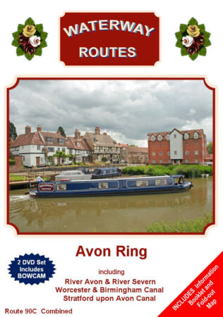
- ∘ Avon Ring DVDs (1)
- ∘ Aylesbury Arm DVDs (GU Canal) (1)
- ∘ Basingstoke Canal DVDs (1)
- ∘ Bedford & Milton Keynes Watrwy DVDs (1)
- ∘ Bevills Leam DVDs (Middle Levels) (1)
- ► Birmingham & Fazeley Canal DVDs (3)
- ► Birmingham Canal Navs (BCN) DVDs (2)
- ∘ Anglesey Branch DVDs (1)
- ∘ Boshboil Branch DVDs (1)
- ∘ Bradley Arm DVDs (1)
- ∘ Cannock Extension Canal DVDs (1)
- ∘ Daw End Branch DVDs (1)
- ∘ Dudley No 1 Canal DVDs (1)
- ∘ Dudley No 2 Canal DVDs (1)
- ∘ Engine Arm DVDs (1)
- ∘ Gower Branch DVDs (1)
- ∘ Icknield Port Loop DVDs (1)
- ∘ Main Line DVDs (2)
- ∘ Netherton Tunnel Branch DVDs (1)
- ∘ New Main Line DVDs (1)
- ∘ Old Main Line DVDs (2)
- ∘ Oozells Street Loop DVDs (1)
- ∘ Rushall Canal DVDs (1)
- ∘ Soho Loop DVDs (1)
- ∘ Spon Lane Branch DVDs (1)
- ∘ Tame Valley Canal DVDs (1)
- ∘ Birmingham Mini Ring DVDs (1)
- ∘ Black Country Ring DVDs (1)
- ∘ Boshboil Branch DVDs (BCN) (1)
- ∘ Bradley Arm DVDs (BCN) (1)
- ► Bridgewater Canal DVDs (1)
- ∘ Burwell Lode DVDs (Cam) (1)
- ► Calder & Hebble Navigation DVDs (1)
- ► Caldon Canal DVDs (1)
- ∘ Cannock Extension Canal DVDs (BCN) (1)
- ∘ Cheshire Ring DVDs (1)
- ► Chesterfield Canal DVDs (1)
- ∘ Coventry Canal DVDs (2)
- ∘ Daw End Branch DVDs (BCN) (1)
- ∘ Digbeth Branch DVDs (B&F Canal) (1)
- ∘ Digbeth Branch DVDs (GU Canal) (2)
- ∘ Droitwich Barge Canal DVDs (2)
- ∘ Droitwich Canals DVDs (1)
- ∘ Droitwich Junction Canal DVDs (2)
- ∘ Dudley No 1 Canal DVDs (BCN) (1)
- ∘ Dudley No 2 Canal DVDs (BCN) (1)
- ∘ Duke's Cut DVDs (Oxford Canal) (1)
- ∘ East Midlands (Leicester) Ring DVDs (1)
- ∘ Ellesmere Branch DVDs (Llangollen Cnl) (1)
- ∘ Engine Arm DVDs (BCN) (1)
- ∘ Erewash Canal DVDs (1)
- ► Forth & Clyde Canal DVDs (1)
- ∘ Forty Foot DVDs (Middle Levels) (1)
- ∘ Four Counties Ring DVDs (1)
- ∘ Glasgow Branch DVDs (F&C Canal) (1)
- ∘ Glasson Branch DVDs (Lancaster Canal) (1)
- ∘ Gloucester & Sharpness Canal DVDs (1)
- ∘ Gower Branch DVDs (BCN) (1)
- ► Grand Union Canal (Leicstr Sec) DVDs (2)
- ► Grand Union Canal (North) DVDs (4)
- ► Grand Union Canal (South) DVDs (2)
- ∘ Grand Union Canal DVDs (1)
- ∘ Great Raveley Drain DVDs (Mid Lvls) (1)
- ∘ Halifax Arm DVDs (C&H Navigation) (1)
- ∘ Hertford Union Canal DVDs (GU Canal) (1)
- ∘ Huddersfield Broad Canal DVDs (1)
- ∘ Huddersfield Canals DVDs (1)
- ∘ Huddersfield Narrow Canal DVDs (1)
- ∘ Icknield Port Loop DVDs (BCN) (1)
- ► Kennet & Avon Canal DVDs (1)
- ∘ Kings Dyke DVDs (Middle Levels) (1)
- ∘ Lady Lee Arm DVDs (Chesterfield Canal) (1)
- ► Lancaster Canal DVDs (1)
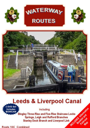
- ► Leeds & Liverpool Canal DVDs (1)
- ∘ Leek Branch DVDs (Caldon Canal) (1)
- ∘ Leigh Branch DVDs (Bridgewater Canal) (1)
- ∘ Leigh Branch DVDs (L&L Canal) (1)
- ∘ Liverpool Link DVDs (L&L Canal) (1)
- ► Llangollen Canal DVDs (1)
- ∘ Loughborough Arm DVDs (GU Lcstr Sec) (1)
- ∘ Macclesfield Canal DVDs (1)
- ∘ Main Drain DVDs (Middle Levels) (1)
- ∘ Main Line DVDs (BCN) (1)
- ∘ Market Harboro’ Arm DVDs (GU Lcstr) (2)
- ∘ Mid Worcs (Droitwich) Ring DVDs (1)
- ► Middle Level Navigations DVDs (1)
- ∘ Bevills Leam DVDs (1)
- ∘ Forty Foot DVDs (1)
- ∘ Great Raveley Drain DVDs (1)
- ∘ Kings Dyke DVDs (1)
- ∘ Main Drain DVDs (1)
- ∘ Monk’s Lode DVDs (1)
- ∘ New Dyke DVDs (1)
- ∘ New Pophams Eau DVDs (1)
- ∘ Ramsey High Lode DVDs (1)
- ∘ River Nene Old Course DVDs (1)
- ∘ Sixteen Foot DVDs (1)
- ∘ Twenty Foot DVDs (1)
- ∘ Well Creek DVDs (1)
- ∘ Whittlesey Dyke DVDs (1)
- ∘ Middlewich Brnch DVDs (Shrp Un Cnl) (1)
- ∘ Monk’s Lode DVDs (Middle Levels) (1)
- ∘ Netherton Tunnel Branch DVDs (BCN) (1)
- ∘ New Bedford River DVDs (1)
- ∘ New Dyke DVDs (Middle Levels) (1)
- ∘ New Main Line DVDs (BCN) (1)
- ∘ New Pophams Eau DVDs (Middle Lvls) (1)
- ∘ Norbriggs Arm DVDs (Chesterfld Cnl) (1)
- ∘ Northampton Arm DVDs (GU Canal) (1)
- ∘ Northern Reaches DVDs (Lancaster Cnl) (1)
- ∘ Old Main Line DVDs (BCN) (1)
- ∘ Oozells Street Loop DVDs (BCN) (1)
- ► Oxford Canal DVDs (2)
- ∘ Paddington Arm DVDs (GU Canal) (1)
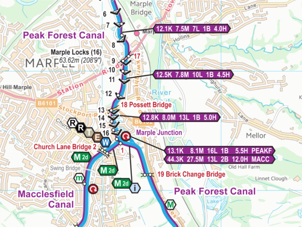
- ► Peak Forest Canal DVDs (1)
- ∘ Prees Branch DVDs (Llangollen Canal) (1)
- ∘ Ramsey High Lode DVDs (Middle Lvls) (1)
- ∘ Reach Lode DVDs (Cam) (1)
- ∘ Reading Loop DVDs (K&A Canal) (1)
- ∘ Regents Canal DVDs (GU Canal) (1)
- ∘ Relief Channel DVDs (Great Ouse) (1)
- ∘ Ribble Link DVDs (Lancaster Canal) (1)
- ► Rings DVDs (10)
- ∘ Avon Ring DVDs (1)
- ∘ Birmingham Mini Ring DVDs (1)
- ∘ Black Country Ring DVDs (1)
- ∘ Cheshire Ring DVDs (1)
- ∘ East Midlands (Leicester) Ring DVDs (1)
- ∘ Four Counties Ring DVDs (1)
- ∘ Mid Worcs (Droitwich) Ring DVDs (1)
- ∘ South Pennine Ring DVDs (1)
- ∘ Stourport Ring DVDs (1)
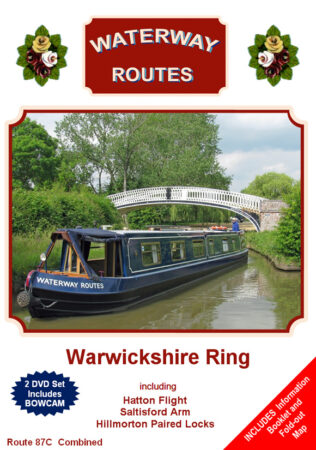
- ∘ Warwickshire Ring DVDs (1)
- ∘ River Avon (Bristol) DVDs (1)
- ∘ River Avon (Stratford) DVDs (1)
- ► River Cam DVDs (1)
- ► River Great Ouse DVDs (1)
- ∘ River Lark DVDs (1)
- ∘ River Little Ouse DVDs (1)
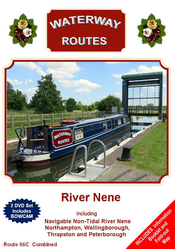
- ∘ River Nene DVDs (1)
- ∘ River Nene Old Course DVDs (Mid Lvls) (1)
- ∘ River Salwarpe DVDs (2)
- ∘ River Severn DVDs (3)
- ∘ River Trent DVDs (1)
- ∘ River Wey DVDs (1)
- ∘ River Wissey DVDs (1)
- ∘ Rochdale Canal DVDs (2)
- ∘ Rufford Branch DVDs (L&L Canal) (1)
- ∘ Rushall Canal DVDs (BCN) (1)
- ∘ Saltisford Arm DVDs (GU Canal) (1)
- ∘ Sheepwash Channel DVDs (Oxford Cnl) (1)
- ► Shropshire Union Canal DVDs (1)
- ∘ Sixteen Foot DVDs (Middle Levels) (1)
- ∘ Slough Arm DVDs (GU Canal) (1)
- ∘ Soho Loop (BCN) DVDs (1)
- ∘ South Pennine Ring DVDs (1)
- ∘ Spon Lane Branch DVDs (BCN) (1)
- ∘ Springs Branch DVDs (L&L Canal) (1)
- ∘ Staffs & Worcester Canal DVDs (2)
- ∘ Stanley Dock Branch DVDs (L&L Canal) (1)
- ∘ Stourport Ring DVDs (1)
- ∘ Stratford upon Avon Canal DVDs (2)
- ∘ Tame Valley Canal DVDs (BCN) (1)
- ∘ Trent & Mersey Canal DVDs (4)
- ∘ Trevor Branch DVDs (1)
- ∘ Twenty Foot DVDs (Middle Levels) (1)
- ∘ Union Canal DVDs (1)
- ∘ Warwickshire Ring DVDs (1)
- ∘ Welford Arm DVDs (GU Leicstr Sctn) (2)
- ∘ Well Creek DVDs (Middle Levels) (1)
- ∘ Wendover Arm DVDs (GU Canal) (1)
- ∘ Whaley Bridge Brch DVDs (Pk Frst Cnl) (1)
- ∘ Whitchurch Branch DVDs (1)
- ∘ Whittlesey Dyke DVDs (Middle Levels) (1)
- ∘ Wicken Lode DVDs (Cam) (1)
- ∘ Worcester & Birmingham Canal DVDs (3)
- ► FAQ - Frequently Asked Questions (4)
- ► Feedback (1)
- ► Hire Bases (7)
- ► MAPS (110)
- ∘ Free Maps for Restoration Projects (1)
- ∘ Map of Maps (1)
- ∘ ENGLAND & WALES MAP (1)
- ∘ Abbey Creek Maps (Bow Creek) (1)
- ► Aire & Calder Navigation Maps (1)
- ∘ Anglesey Branch Maps (BCN) (1)
- ∘ Ashby Canal Maps (2)
- ∘ Ashton Canal Maps (1)
- ∘ Avon Ring Maps (1)
- ∘ Aylesbury Arm Maps (GU Canal) (2)
- ∘ Barnsley Canal Maps (1)
- ∘ Basingstoke Canal Maps (1)
- ∘ Beat Bank Branch Maps (Stockport Cnl) (1)
- ∘ Bedford & Milton Keynes Watrwy Maps (2)
- ∘ Beeston Canal Maps (1)
- ∘ Bevills Leam Maps (Middle Levels) (1)
- ∘ Billinghay Skirth Maps (River Witham) (1)
- ► Birmingham & Fazeley Canal Maps (1)
- ► Birmingham Canal Navs (BCN) Maps (2)
- ∘ Anglesey Branch Maps (1)
- ∘ Boshboil Branch Maps (1)
- ∘ Bradley Arm Maps (2)
- ∘ Bradley Canal Maps (2)
- ∘ Bumblehole Branch Maps (1)
- ∘ Cannock Extension Canal Maps (1)
- ∘ Causeway Green Branch Maps (1)
- ∘ Daw End Branch Maps (1)
- ∘ Dudley No 1 Canal Maps (1)
- ∘ Dudley No 2 Canal Maps (1)
- ∘ Engine Arm Maps (1)
- ∘ Gower Branch Maps (1)
- ∘ Icknield Port Loop Maps (1)
- ∘ Main Line Maps (1)
- ∘ Netherton Tunnel Branch Maps (1)
- ∘ New Main Line Maps (1)
- ∘ Old Main Line Maps (1)
- ∘ Oozells Street Loop Maps (1)
- ∘ Portway Branch Maps (1)
- ∘ Rushall Canal Maps (1)
- ∘ Soho Branch Maps (1)
- ∘ Soho Loop Maps (1)
- ∘ Spon Lane Branch Maps (1)
- ∘ Tame Valley Canal Maps (1)
- ∘ Birmingham Mini Ring Maps (1)
- ∘ Black Country Ring Maps (1)
- ∘ Black Ham Maps (Middle Levels) (1)
- ∘ Blackbrook Branch Maps (St Helens Cnl) (1)
- ∘ Boardmans Brdg Brch Maps (St Hlns C) (1)
- ∘ Bolton Branch Maps (MB&B Canal) (1)
- ∘ Boshboil Branch Maps (BCN) (1)
- ► Bow Creek Maps (1)
- ∘ Bradford Canal Maps (1)
- ∘ Bradley Arm Maps (BCN) (2)
- ∘ Bradley Canal Maps (BCN) (2)
- ∘ Bray Cut Maps (River Thames) (2)
- ∘ Brecknock & Abergavenny Cnl Maps (1)
- ► Bridgewater Canal Maps (1)
- ∘ Bridgwater & Taunton Canal Maps (2)
- ∘ Buckingham Canal Maps (1)
- ∘ Bumblehole Branch Maps (BCN) (1)
- ∘ Burwell Lode Maps (Cam) (1)
- ∘ Bury Branch Maps (MB&B Canal) (1)
- ► Calder & Hebble Navigation Maps (2)
- ► Caldon Canal Maps (1)
- ∘ Calne Branch Maps (WB Canal) (1)
- ∘ Cannock Extension Canal Maps (BCN) (1)
- ∘ Causeway Green Branch Maps (BCN) (1)
- ∘ Channelsea River Maps (Bow Creek) (1)
- ∘ Chard Canal Maps (2)
- ∘ Cheshire Ring Maps (1)
- ► Chesterfield Canal Maps (2)
- ∘ Chippenham Branch Maps (WB Canal) (1)
- ∘ Cirencester Arm Maps (T&S Canal) (1)
- ∘ City Mill River Maps (River Lee) (1)
- ∘ Coal Branch Maps (H&G Canal) (1)
- ∘ Coalbrookdale Brnch Maps (Shrpshr Cnl) (1)
- ∘ Coronation Channel Maps (Welland) (1)
- ∘ Cotswold Canals Maps (1)
- ∘ Coventry Canal Maps (1)
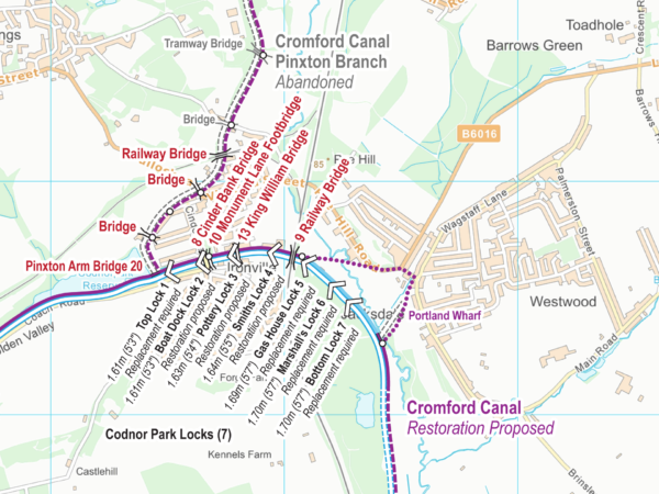
- ► Cromford Canal Maps (1)
- ∘ Crumlin Arm Maps (Monmouthshire Cnl) (2)
- ∘ Daventry Canal Maps (1)
- ∘ Daw End Branch Maps (BCN) (1)
- ► Dearne & Dove Canal Maps (1)
- ∘ Dee Branch (Shropshire Union Canal) (1)
- ► Derby Canal Maps (1)
- ∘ Dewsbury Cut Maps (C&H Navigation) (1)
- ∘ Digbeth Branch Maps (B&F Canal) (1)
- ∘ Digbeth Branch Maps (GU Canal) (2)
- ► Donnington Wood Canal Maps (1)
- ∘ Droitwich Barge Canal Maps (1)
- ∘ Droitwich Canals Maps (1)
- ∘ Droitwich Junction Canal Maps (1)
- ∘ Dudley No 1 Canal Maps (BCN) (1)
- ∘ Dudley No 2 Canal Maps (BCN) (1)
- ∘ Duke's Cut Maps (Oxford Canal) (1)
- ∘ East Midlands Ring Maps (1)
- ∘ Ellesmere Branch Maps (Llangollen Cnl) (1)
- ∘ Elsecar Branch Maps (D&D Canal) (1)
- ∘ Engine Arm Maps (BCN) (1)
- ∘ Erewash Canal Maps (2)
- ∘ Fairbottom Branch Maps (Hollinwd Cnl) (1)
- ∘ Fens Branch Maps (Stourbridge Canal) (1)
- ∘ Fletcher's Canal Maps (1)
- ► Forth & Clyde Canal Maps (1)
- ∘ Forty Foot Maps (Middle Levels) (1)
- ∘ Fossdyke & Witham Navigation Maps (1)
- ∘ Fossdyke Navigation Maps (1)
- ∘ Four Counties Ring Maps (1)
- ∘ Gerard's Brdg Brnch Maps (St Hlns Cnl) (1)
- ∘ Gibson's Cut Maps (Horncastle Canal) (2)
- ∘ Glasgow Branch Maps (F&C Canal) (1)
- ∘ Glasson Branch Maps (Lancaster Canal) (1)
- ∘ Gloucester & Sharpness Canal Maps (1)
- ∘ Gower Branch Maps (BCN) (1)
- ∘ Grand Union Canal (All) Maps (1)
- ► Grand Union Canal (Main) Maps (4)
- ∘ Grand Union Canal (North) Maps (2)
- ∘ Grand Union Canal (South) Maps (2)
- ∘ Aylesbury Arm Maps (2)
- ∘ Digbeth Branch Maps (2)
- ∘ Hertford Union Canal Maps (2)
- ∘ Northampton Arm Maps (2)
- ∘ Paddington Arm Maps (2)
- ∘ Regents Canal Maps (2)
- ∘ Saltisford Arm Maps (2)
- ∘ Slough Arm Maps (2)
- ∘ Wendover Arm Maps (3)
- ► Grand Union Canal (Leicester) Maps (2)
- ∘ Grand Western Canal Maps (2)
- ∘ Grantham Canal Maps (1)
- ∘ Great Raveley Drain Maps (Mid Lvls) (1)
- ∘ Guilsfield Arm Maps (Montgomery Canal) (1)
- ∘ Halifax Arm Maps (C&H Navigation) (2)
- ∘ Hatherton Canal Maps (1)
- ► Hereford & Gloucester Canal Maps (1)
- ∘ Hertford Union Canal Maps (GU Canal) (2)
- ► Hollinwood Canal Maps (1)
- ► Horncastle Canal Maps (3)
- ∘ Horsehay Brnch Maps (Shrpshr Cnl) (1)
- ∘ Huddersfield Broad Canal Maps (2)
- ∘ Huddersfield Canals Maps (2)
- ∘ Huddersfield Narrow Canal Maps (2)
- ∘ Hulme Locks Branch Maps (Brdgwtr Cnl) (1)
- ∘ Humber Branch Maps (Newport Canal) (1)
- ∘ Hunloke's Arm Maps (Nutbrook Canal) (1)
- ∘ Icknield Port Loop Maps (BCN) (1)
- ∘ Ivelchester & Langport Nav Maps (2)
- ► Kennet & Avon Canal Maps (1)
- ∘ Ketley Canal Maps (1)
- ∘ Kings Dyke Maps (Middle Levels) (1)
- ∘ Kingswood Branch Maps (Stratford Cnl) (1)
- ∘ Lady Lee Arm Maps (Chesterfield Canal) (1)
- ► Lancaster Canal Maps (3)
- ∘ Lapal Canal Maps (1)
- ∘ Lapworth Link Maps (Stratford Cnl) (1)
- ∘ Lea Wood Branch Maps (Cromfd Canal) (1)
- ► Leeds & Liverpool Canal Maps (2)
- ∘ Leek Branch Maps (Caldon Canal) (1)
- ∘ Leicester Ring Maps (1)
- ∘ Leigh Branch Maps (Bridgewater Canal) (1)
- ∘ Leigh Branch Maps (L&L Canal) (1)
- ∘ Lichfield Canal Maps (1)
- ∘ Lilleshall Arm Maps (Dngtn Wd Cnl) (1)
- ∘ Lilleshall Branch Maps (Dngtn Wd Cnl) (1)
- ∘ Little Eaton Branch Maps (Derby Canal) (1)
- ∘ Liverpool Link Maps (L&L Canal) (1)
- ► Llangollen Canal Maps (1)
- ∘ Longcot Arm Maps (WB Canal) (1)
- ∘ Loughborough Arm Maps (GU Lcstr Sctn) (2)
- ∘ Macclesfield Canal Maps (1)
- ∘ Maidenhead Ditch Maps (River Thames) (2)
- ∘ Main Drain Maps (Middle Levels) (1)
- ∘ Main Line Maps (BCN) (1)
- ► Manchester Bolton & Bury Cnl Maps (1)
- ∘ Manchester Ship Canal Maps (1)
- ∘ Market Harboro' Arm Maps (GU Lcstr) (2)
- ∘ Melton Mowbray Navigation Maps (1)
- ∘ Mid Worcestershire Ring Maps (1)
- ► Middle Level Navigations Maps (1)
- ∘ Bevills Leam Maps (1)
- ∘ Black Ham Maps (1)
- ∘ Forty Foot Maps (1)
- ∘ Great Raveley Drain Maps (1)
- ∘ Kings Dyke Maps (1)
- ∘ Main Drain Maps (1)
- ∘ Monk's Lode Maps (1)
- ∘ New Dyke Maps (1)
- ∘ New Pophams Eau Maps (1)
- ∘ Old Pophams Eau (1)
- ∘ Ramsey High Lode Maps (1)
- ∘ River Nene Old Course Maps (1)
- ∘ Sixteen Foot Maps (1)
- ∘ Twenty Foot Maps (1)
- ∘ Well Creek Maps (1)
- ∘ Whittlesey Dyke Maps (1)
- ∘ Yaxley Lode (1)
- ∘ Middlewich Branch (Shrpshr Union Cnl) (1)
- ∘ Monk's Lode Maps (Middle Levels) (1)
- ∘ Monmouth & Brecon Canal Maps (2)
- ► Monmouthshire Canal Maps (2)
- ► Montgomery Canal Maps (1)
- ∘ Moor Cut Maps (River Thames) (2)
- ∘ Netherton Tunnel Branch Maps (BCN) (1)
- ∘ New Bedford River Maps (1)
- ∘ New Dyke Maps (Middle Levels) (1)
- ∘ New Junction Canal Maps (SSY Navs) (1)
- ∘ New Main Line Maps (BCN) (1)
- ∘ New Pophams Eau Maps (Middle Levels) (1)
- ∘ Newcastle-under-Lyme Canal Maps (1)
- ► Newport Canal Maps (2)
- ∘ Norbriggs Arm Maps (Chesterfield Canal) (2)
- ∘ North Walsham & Dilham Canal Maps (1)
- ∘ North Wilts Canal Maps (WB Canal) (1)
- ∘ Northampton Arm Maps (GU Canal) (2)
- ∘ Northern Reaches Maps (Lancaster Cnl) (2)
- ► Nottingham Canal Maps (2)
- ► Nutbrook Canal Maps (1)
- ∘ Oakham Canal Maps (1)
- ∘ Old Main Line Maps (BCN) (1)
- ∘ Old Pophams Eau Maps (Middle Levels) (1)
- ∘ Old River Lee Maps (River Lee) (1)
- ∘ Oozells Street Loop Maps (BCN) (1)
- ► Oxford Canal Maps (1)
- ∘ Paddington Arm Maps (GU Canal) (2)
- ► Peak Forest Canal Maps (1)
- ∘ Pinxton Branch Maps (Cromford Canal) (1)
- ∘ Pitchcroft Branch Maps (Dngtn Wd Cnl) (1)
- ∘ Plas Kynaston Canal Maps (1)
- ∘ Pocklington Canal Maps (2)
- ∘ Pomona Lock Brnch Maps (Brgwtr Cnl) (1)
- ∘ Portsmouth & Arundel Canal Maps (1)
- ∘ Portway Branch Maps (BCN) (1)
- ∘ Prees Branch Maps (Llangollen Canal) (1)
- ∘ Prescott Channel Maps (Bow Creek) (1)
- ∘ Preston Brook Brnch Maps (Brdgwtr Cnl) (1)
- ∘ Ramsey High Lode Maps (Middle Levels) (1)
- ∘ Ravenhead Branch Maps (St Hlns Cnl) (1)
- ∘ Ravenhead Canal Maps (1)
- ∘ Reach Lode Maps (Cam) (1)
- ∘ Reading Loop Maps (K&A Canal) (1)
- ∘ Regents Canal Maps (GU Canal) (2)
- ∘ Relief Channel Maps (Great Ouse) (1)
- ∘ Ribble Link Maps (Lancaster Canal) (1)
- ► Rings Maps (10)
- ∘ Avon Ring Maps (1)
- ∘ Birmingham Mini Ring Maps (1)
- ∘ Black Country Ring Maps (1)
- ∘ Cheshire Ring Maps (1)
- ∘ East Midlands Ring Maps (1)
- ∘ Four Counties Ring Maps (1)
- ∘ Leicester Ring Maps (1)
- ∘ Mid Worcestershire Ring Maps (1)
- ∘ South Pennine Ring Maps (1)
- ∘ Stourport Ring Maps (1)
- ∘ Warwickshire Ring Maps (1)
- ∘ Ripon Canal Maps (1)
- ∘ River Aire Maps (1)
- ∘ River Arun Maps (1)
- ∘ River Avon (Bristol) Maps (1)
- ∘ River Avon (Stratford) Maps (2)
- ► River Cam Maps (1)
- ∘ River Dee maps (1)
- ∘ River Derwent (Derbyshire) Maps (1)
- ∘ River Derwent (Yorkshire) Maps (1)
- ∘ River Don Maps (SSY Navigations) (1)
- ∘ River Foss Maps (2)
- ∘ River Glen Maps (1)
- ► River Great Ouse Maps (1)
- ∘ River Idle Maps (1)
- ∘ River Irwell Maps (1)
- ∘ River Ivel Maps (2)
- ∘ River Lark Maps (1)
- ► River Lee Navigation Maps (1)
- ∘ River Little Ouse Maps (1)
- ∘ River Mersey Maps (1)
- ∘ River Nene Maps (1)
- ∘ River Nene Old Course Maps (Mid Lvls) (1)
- ∘ River Ouse Maps (1)
- ∘ River Parrett Maps (2)
- ∘ River Rother Maps (2)
- ∘ River Salwarpe Maps (1)
- ∘ River Severn Maps (1)
- ∘ River Slea Maps (2)
- ∘ River Soar Maps (2)
- ∘ River Stort Navigation Maps (1)
- ► River Thames Maps (3)
- ∘ River Tone Maps (2)
- ∘ River Trent Maps (1)
- ∘ River Ure Maps (1)
- ∘ River Weaver Maps (1)
- ► River Welland Maps (1)
- ∘ River Wey Maps (1)
- ∘ River Wissey Maps (1)
- ► River Witham Maps (1)
- ∘ Robbinetts Arm Maps (Nottnghm Canal) (1)
- ∘ Rochdale Canal Maps (2)
- ∘ Rufford Branch Maps (L&L Canal) (1)
- ∘ Runcorn & Weston Canal Maps (1)
- ∘ Runcorn New Locks Maps (Brdgwtr Cnl) (1)
- ∘ Rushall Canal Maps (BCN) (1)
- ∘ Saltisford Arm Maps (GU Canal) (2)
- ∘ Selby Canal Maps (1)
- ∘ Sheepwash Channel Maps (Oxfd Cnl) (1)
- ► Sheffield & South Yorks Navs Maps (1)
- ∘ Sheffield & Tinsly Cnl Maps (SSY Nav) (1)
- ∘ Shrewsbury and Newport Cnls Maps (1)
- ► Shrewsbury Canal Maps (1)
- ► Shropshire Canal Maps (1)
- ► Shropshire Union Canal Maps (1)
- ∘ Sir Nigel Gresley's Canal Maps (1)
- ∘ Sixteen Foot Maps (Middle Levels) (1)
- ∘ Slough Arm Maps (GU Canal) (2)
- ∘ Soho Branch Maps (BCN) (1)
- ∘ Soho Loop (BCN) Maps (1)
- ∘ Somersetshire Coal Canal Maps (1)
- ∘ South Pennine Ring Maps (1)
- ∘ Spon Lane Branch Maps (BCN) (1)
- ∘ Springs Branch Maps (L&L Canal) (1)
- ► St Helens Canal Maps (1)
- ∘ St Thomas Creek Maps (River Lee) (1)
- ∘ Stafford Riverway Link Maps (1)
- ∘ Staffs & Worcester Canal Maps (1)
- ∘ Stainforth & Keadby Cnl Maps (SSY Nav) (1)
- ∘ Stanhope's Arm Maps (Nutbrook Canal) (1)
- ∘ Stanley Dock Branch Maps (L&L Canal) (1)
- ► Stockport Canal Maps (1)
- ► Stourbridge Canal Maps (1)
- ∘ Stourbridge Extnsn Cnl Maps (Strbg Cnl) (1)
- ∘ Stourbridge Town Arm Maps (Strbg Cnl) (1)
- ∘ Stourport Ring Maps (1)
- ► Stratford upon Avon Canal Maps (1)
- ∘ Stroudwater Canal Maps (1)
- ∘ Tame Valley Canal Maps (BCN) (1)
- ► Thames & Severn Canal Maps (1)
- ∘ The Wash Maps (1)
- ∘ Three Mills River Maps (Bow Creek) (1)
- ∘ Timberland Delph Maps (River Witham) (1)
- ∘ Trench Branch Maps (Shrewsbury Canal) (1)
- ∘ Trent & Mersey Canal Maps (2)
- ∘ Trevor Branch Maps (Llangollen Canal) (1)
- ∘ Twenty Foot Maps (Middle Levels) (1)
- ∘ Union Canal Maps (1)
- ∘ Uttoxeter Canal Maps (1)
- ∘ Wakefield Branch Maps (A&C Navigtn) (1)
- ∘ Walton Summit Branch Maps (1)
- ∘ Wantage Arm Maps (WB Canal) (1)
- ∘ Warwickshire Ring Maps (1)
- ∘ Waterworks River Maps (Bow Creek) (1)
- ∘ Welford Arm Maps (GU Leicstr Sctn) (2)
- ∘ Well Creek Maps (Middle Levels) (1)
- ∘ Wendover Arm Maps (GU Canal) (3)
- ∘ Werneth Branch Canal Maps (1)
- ∘ Weston Branch Maps (Montgomery Cnl) (1)
- ∘ Westport Canal Maps (2)
- ∘ Wey & Arun Canal Maps (1)
- ∘ Whaley Bridge Brnch Maps (Pk Frst Cnl) (1)
- ∘ Whitchurch Brnch Maps (Llanglln Cnl) (1)
- ∘ Whittlesey Dyke Maps (Middle Levels) (1)
- ∘ Wicken Lode Maps (Cam) (1)
- ► Wilts & Berks Canal Maps (1)
- ∘ Wisbech Canal Maps (1)
- ∘ Wombridge Canal Maps (1)
- ∘ Worcester & Birmingham Canal Maps (1)
- ∘ Yaxley Lode Maps (Middle Levels) (1)
- ∘ York Stream Maps (River Thames) (2)
- ► MAPS - Formats and Support (19)
- ► MAPs - Updates and Upgrades (122)
- ► Narrowboat Waterway Routes (21)
- ► Photos (484)
- ∘ Anglesey Branch Photos (BCN) (2)
- ∘ Ashby Canal Photos (45)
- ∘ Ashton Canal Photos (12)
- ► Birmingham & Fazeley Canal Photos (24)
- ► Birmingham Cnl Navs (BCN) Photos (241)
- ∘ Anglesey Branch Photos (2)
- ∘ Boshboil Branch Photos (2)
- ∘ Bradley Arm Photos (25)
- ∘ Bradley Canal Photos (20)
- ∘ Gower Branch Photos (6)
- ∘ Icknield Port Loop Photos (9)
- ∘ Main Line Photos (64)
- ∘ New Main Line Photos (38)
- ∘ Old Main Line Photos (44)
- ∘ Oozells Street Loop Photos (8)
- ∘ Soho Branch Photos (5)
- ∘ Soho Loop Photos (12)
- ∘ Spon Lane Branch Photos (6)
- ∘ Wednesbury Oak Loop Photos (25)
- ∘ Boshboil Branch Photos (BCN) (2)
- ∘ Bradley Arm Photos (BCN) (25)
- ∘ Bradley Canal Photos (BCN) (20)
- ∘ Bridgewater Canal Photos (2)
- ► Caldon Canal Photos (42)
- ∘ Coventry Canal Photos (36)
- ∘ Digbeth Branch Photos (B&F Canal) (4)
- ∘ Erewash Canal Photos (1)
- ► Forth & Clyde Canal Photos (31)
- ∘ Gerard's Bridge Branch Photos (1)
- ∘ Glasgow Branch Photos (F&C Canal) (1)
- ∘ Gower Branch Photos (BCN) (6)
- ∘ Hereford & Gloucester Canal Photos (1)
- ∘ Hollinwood Canal Photos (2)
- ∘ Icknield Port Loop Photos (BCN) (9)
- ∘ Lapal Canal Photos (1)
- ∘ Leek Branch Photos (Caldon Canals) (5)
- ∘ Main Line Photos (BCN) (64)
- ∘ New Main Line Photos (BCN) (38)
- ∘ Nutbrook Canal Photos (1)
- ∘ Old Main Line Photos (BCN) (44)
- ∘ Oozells Street Loop Photos (BCN) (8)
- ∘ River Foss Photos (15)
- ∘ Soho Branch Photos (BCN) (5)
- ∘ Soho Loop Photos (BCN) (12)
- ∘ Spon Lane Branch Photos (BCN) (6)
- ► St Helens Canal Photos (2)
- ∘ Staffs & Worcester Canal Photos (9)
- ∘ Union Canal Photos (19)
- ∘ Wednesbury Oak Loop Photos (BCN) (25)
- ► Virtual Cruises (VC) (211)
- ∘ Ashby Canal VC (1)
- ∘ Ashton Canal VC (1)
- ► Birmingham & Fazeley Canal VC (2)
- ► Birmingham Cnl Navgtns (BCN) VC (60)
- ∘ Bradley Arm VC (1)
- ∘ Bradley Canal VC (1)
- ∘ Bumblehole Branch VC (2)
- ∘ Cannock Extension Canal VC (2)
- ∘ Causeway Green Branch VC (2)
- ∘ Daw End Branch VC (2)
- ∘ Dudley No 1 Canal VC (2)
- ∘ Dudley No 2 Canal VC (4)
- ∘ Engine Arm VC (2)
- ∘ Gower Branch VC (1)
- ∘ Icknield Port Loop VC (1)
- ∘ Main Line VC (2)
- ∘ Netherton Tunnel Branch VC (2)
- ∘ New Main Line VC (2)
- ∘ Old Main Line VC (2)
- ∘ Oozells Street Loop VC (1)
- ∘ Rushall Canal VC (2)
- ∘ Soho Branch VC (2)
- ∘ Soho Loop VC (1)
- ∘ Spon Lane Branch VC (3)
- ∘ Tame Valley Canal VC (3)
- ∘ Titford Canal VC (4)
- ∘ Walsall Canal VC (5)
- ∘ Walsall Town Arm VC (2)
- ∘ Wednesbury Oak Loop VC (1)
- ∘ Wednesbury Old Canal VC (3)
- ∘ Wyrley & Essington Canal VC (6)
- ∘ Bradley Arm (BCN) VC (1)
- ∘ Bradley Canal (BCN) VC (1)
- ∘ Bumblehole Branch (BCN) VC (2)
- ► Caldon Canal VC (1)
- ∘ Cannock Extension Canal (BCN) VC (2)
- ∘ Causeway Green Branch (BCN) VC (2)
- ∘ Coventry Canal VC (1)
- ∘ Daw End Branch (BCN) VC (2)
- ∘ Digbeth Branch (B&F Canal) VC (1)
- ∘ Digbeth Branch (GU Canal) VC (2)
- ∘ Dudley No 1 Canal (BCN) VC (2)
- ∘ Dudley No 2 Canal (BCN) VC (4)
- ∘ Engine Arm (BCN) VC (2)
- ∘ Fairbottom Branch (Hollinwd Cnl) VC (14)
- ► Forth & Clyde Canal VC (1)
- ∘ Glasgow Branch VC (Forth & Clyde) (1)
- ∘ Gower Branch (BCN) VC (1)
- ► Grand Union Canal VC (4)
- ∘ Hatherton Canal VC (2)
- ► Hollinwood Canal VC (64)
- ∘ Icknield Port Loop (BCN) VC (1)
- ∘ Leek Branch VC (Caldon Canal) (1)
- ∘ Lichfield Canal VC (2)
- ∘ Main Line (BCN) VC (2)
- ∘ Netherton Tunnel Branch (BCN) VC (2)
- ∘ New Main Line (BCN) VC (2)
- ∘ Nutbrook Canal VC (15)
- ∘ Old Main Line (BCN) VC (2)
- ∘ Oozells Street Loop (BCN) VC (1)
- ∘ River Foss (2)
- ► River Thames VC (38)
- ∘ Rushall Canal (BCN) VC (2)
- ∘ Soho Branch (BCN) VC (2)
- ∘ Soho Loop (BCN) VC (1)
- ∘ Spon Lane Branch (BCN) VC (3)
- ∘ Staffs & Worcester Canal VC (1)
- ∘ Tame Valley Canal (BCN) VC (3)
- ∘ Titford Canal (BCN) VC (4)
- ∘ Trent & Mersey Canal VC (2)
- ∘ Union Canal VC (1)
- ∘ Walsall Canal (BCN) VC (5)
- ∘ Walsall Town Arm (BCN) VC (2)
- ∘ Wednesbury Oak Loop (BCN) VC (1)
- ∘ Wednesbury Old Canal (BCN) VC (3)
- ∘ Werneth Branch Canal VC (4)
- ∘ Worcester & Birmingham Canal VC (10)
- ∘ Wyrley & Essington Canal (BCN) VC (6)
- ► WATERWAYS (397)
- ∘ Abbey Creek (Bow Creek) (1)
- ► Aire & Calder Navigation (1)
- ∘ Anglesey Branch (BCN) (2)
- ∘ Ashby Canal (4)
- ∘ Ashton Canal (2)
- ∘ Avon Ring (2)
- ∘ Aylesbury Arm (GU Canal) (3)
- ∘ Barnsley Canal (1)
- ∘ Basingstoke Canal (2)
- ∘ Beat Bank Branch (Stockport Canal) (1)
- ∘ Bedford & Milton Keynes Waterway (3)
- ∘ Beeston Canal (1)
- ∘ Bevills Leam (Middle Levels) (2)
- ∘ Billinghay Skirth (River Witham) (1)
- ► Birmingham & Fazeley Canal (4)
- ► Birmingham Canal Navigtns (BCN) (16)
- ∘ Anglesey Branch (2)
- ∘ Boshboil Branch (2)
- ∘ Bradley Arm (4)
- ∘ Bradley Canal (2)
- ∘ Bumblehole Branch (1)
- ∘ Cannock Extension Canal (2)
- ∘ Causeway Green Branch (2)
- ∘ Daw End Branch (2)
- ∘ Dudley No 1 Canal (5)
- ∘ Dudley No 2 Canal (3)
- ∘ Engine Arm (2)
- ∘ Gower Branch (3)
- ∘ Icknield Port Loop (3)
- ∘ Main Line (3)
- ∘ Netherton Tunnel Branch (2)
- ∘ New Main Line (3)
- ∘ Old Main Line (3)
- ∘ Oozells Street Loop (2)
- ∘ Portway Branch (1)
- ∘ Rushall Canal (2)
- ∘ Soho Branch (2)
- ∘ Soho Loop (3)
- ∘ Spon Lane Branch (3)
- ∘ Tame Valley Canal (2)
- ∘ Titford Canal (1)
- ∘ Wednesbury Oak Loop (1)
- ∘ Birmingham Mini Ring (2)
- ∘ Black Country Ring (2)
- ∘ Black Ham (Middle Levels) (1)
- ∘ Blackbrook Branch (St Helens Canal) (13)
- ∘ Boardman's Brdg Brnch (St Helens Cnl) (16)
- ∘ Bolton Branch (MB&B Canal) (1)
- ∘ Boshboil Branch (BCN) (2)
- ► Bow Creek (1)
- ∘ Bradford Canal (1)
- ∘ Bradley Arm (BCN) (4)
- ∘ Bradley Canal (BCN) (2)
- ∘ Bray Cut (River Thames) (2)
- ∘ Brecknock & Abergavenny Canal (1)
- ► Bridgewater Canal (23)
- ∘ Bridgwater & Taunton Canal (1)
- ∘ Buckingham Canal (1)
- ∘ Bumblehole Branch (BCN) (1)
- ∘ Burwell Lode (Cam) (2)
- ∘ Bury Branch (MB&B Canal) (1)
- ► Calder & Hebble Navigation (3)
- ► Caldon Canal (4)
- ∘ Calne Branch (WB Canal) (1)
- ∘ Cannock Extension Canal (BCN) (2)
- ∘ Causeway Green Branch (BCN) (2)
- ∘ Channelsea River (Bow Creek) (1)
- ∘ Chard Canal (1)
- ∘ Cheshire Ring (2)
- ► Chesterfield Canal (4)
- ∘ Chippenham Branch (WB Canal) (1)
- ∘ Cirencester Arm (T&S Canal) (1)
- ∘ City Mill River (River Lee) (1)
- ∘ Coal Branch (H&G Canal) (1)
- ∘ Coalbrookdale Branch (Shropshire Cnl) (1)
- ∘ Coronation Channel (River Welland) (1)
- ∘ Cotswold Canals (1)
- ∘ Coventry Canal (4)
- ► Cromford Canal (1)
- ∘ Crumlin Arm (Monmouthshire Canal) (2)
- ∘ Daventry Canal (1)
- ∘ Daw End Branch (BCN) (2)
- ► Dearne & Dove Canal (1)
- ∘ Dee Branch (Shropshire Union Canal) (1)
- ► Derby Canal (1)
- ∘ Dewsbury Cut (C&H Navigation) (1)
- ∘ Digbeth Branch (B&F Canal) (3)
- ∘ Digbeth Branch (GU Canal) (3)
- ► Donnington Wood Canal (1)
- ∘ Droitwich Barge Canal (3)
- ∘ Droitwich Canals (2)
- ∘ Droitwich Junction Canal (3)
- ∘ Dudley No 1 Canal (BCN) (5)
- ∘ Dudley No 2 Canal (BCN) (3)
- ∘ Duke's Cut (Oxford Canal) (2)
- ∘ East Midlands Ring (2)
- ∘ Ellesmere Branch (Llangollen Canal) (2)
- ∘ Elsecar Branch (D&D Canal) (1)
- ∘ Engine Arm (BCN) (2)
- ∘ Erewash Canal (3)
- ∘ Fairbottom Branch (Hollinwood Cnl) (2)
- ∘ Fens Branch (Stourbridge Canal) (1)
- ∘ Fletcher's Canal (1)
- ► Forth & Clyde Canal (3)
- ∘ Forty Foot (Middle Levels) (2)
- ∘ Fossdyke & Witham Navigation (1)
- ∘ Fossdyke Navigation (1)
- ∘ Four Counties Ring (2)
- ∘ Gerard's Bridge Branch (St Helens Cnl) (11)
- ∘ Gibson's Cut (Horncastle Canal) (2)
- ∘ Glasgow Branch (F&C Canal) (3)
- ∘ Glasson Branch (Lancaster Canal) (2)
- ∘ Gloucester & Sharpness Canal (2)
- ∘ Gower Branch (BCN) (3)
- ► Grand Union Canal (8)
- ► Grand Union Canal (Leicester) (4)
- ∘ Grand Western Canal (1)
- ∘ Grantham Canal (1)
- ∘ Great Raveley Drain (Middle Levels) (2)
- ∘ Guilsfield Arm (Montgomery Canal) (1)
- ∘ Halifax Arm (C&H Navigation) (3)
- ∘ Hatherton Canal (1)
- ► Herefordshire & Gloucestershire Canal (21)
- ∘ Hertford Union Canal (GU Canal) (3)
- ► Hollinwood Canal (6)
- ► Horncastle Canal (3)
- ∘ Horsehay Branch (Shropshire Canal) (1)
- ∘ Huddersfield Broad Canal (3)
- ∘ Huddersfield Canals (3)
- ∘ Huddersfield Narrow Canal (4)
- ∘ Hulme Locks Branch (Brdgwtr Cnl) (10)
- ∘ Humber Branch (Newport Canal) (1)
- ∘ Hunloke's Arm (Nutbrook Canal) (1)
- ∘ Icknield Port Loop (BCN) (3)
- ∘ Ivelchester & Langport Navigation (1)
- ► Kennet & Avon Canal (2)
- ∘ Ketley Canal (1)
- ∘ Kings Dyke (Middle Levels) (2)
- ∘ Kingswood Branch (Stratford Cnl) (1)
- ∘ Lady Lee Arm (Chesterfield Canal) (2)
- ► Lancaster Canal (4)
- ∘ Lapal Canal (30)
- ∘ Lapworth Link (Stratford Canal) (1)
- ∘ Lea Wood Branch (Cromford Canal) (1)
- ► Leeds & Liverpool Canal (4)
- ∘ Leek Branch (Caldon Canal) (4)
- ∘ Leicester Ring (1)
- ∘ Leigh Branch (Bridgewater Canal) (1)
- ∘ Leigh Branch (L&L Canal) (3)
- ∘ Lichfield Canal (1)
- ∘ Lilleshall Arm (Donnington Wood Canal) (1)
- ∘ Lilleshall Branch (Dngtn Wd Cnl) (1)
- ∘ Little Eaton Branch (Derby Canal) (1)
- ∘ Liverpool Link (L&L Canal) (2)
- ► Llangollen Canal (2)
- ∘ Longcot Arm (WB Canal) (1)
- ∘ Loughborough Arm (GU Leicester Sec) (4)
- ∘ Macclesfield Canal (1)
- ∘ Maidenhead Ditch (River Thames) (2)
- ∘ Main Drain (Middle Levels) (2)
- ∘ Main Line (BCN) (3)
- ∘ Manchester & Salford Junction Canal (20)
- ► Manchester Bolton & Bury Canal (1)
- ∘ Manchester Ship Canal (3)
- ∘ Market Harboro' Arm (GU Lcstr Sec) (4)
- ∘ Melton Mowbray Navigation (1)
- ∘ Mid Worcestershire Ring (2)
- ► Middle Level Navigations (2)
- ∘ Bevills Leam (2)
- ∘ Black Ham (1)
- ∘ Forty Foot (2)
- ∘ Great Raveley Drain (2)
- ∘ Kings Dyke (2)
- ∘ Main Drain (2)
- ∘ Monk's Lode (2)
- ∘ New Dyke (2)
- ∘ New Pophams Eau (2)
- ∘ Old Pophams Eau (1)
- ∘ Ramsey High Lode (2)
- ∘ River Nene Old Course (2)
- ∘ Sixteen Foot (2)
- ∘ Twenty Foot (2)
- ∘ Well Creek (2)
- ∘ Whittlesey Dyke (2)
- ∘ Yaxley Lode (1)
- ∘ Middlewich Branch (Shrpshr Union Cnl) (2)
- ∘ Monk's Lode (Middle Levels) (2)
- ∘ Monmouth & Brecon Canal (2)
- ► Monmouthshire Canal (2)
- ► Montgomery Canal (1)
- ∘ Moor Cut (River Thames) (2)
- ∘ Netherton Tunnel Branch (BCN) (2)
- ∘ New Bedford River (2)
- ∘ New Dyke (Middle Levels) (2)
- ∘ New Junction Canal (SSY Navs) (1)
- ∘ New Main Line (BCN) (3)
- ∘ New Pophams Eau (Middle Levels) (2)
- ∘ Newcastle-under-Lyme Canal (1)
- ► Newport Canal (1)
- ∘ Norbriggs Arm (Chesterfield Arm) (3)
- ∘ North Walsham & Dilham Canal (1)
- ∘ North Wilts Canal (WB Canal) (1)
- ∘ Northampton Arm (GU Canal) (3)
- ∘ Northern Reaches (Lancaster Canal) (3)
- ► Nottingham Canal (2)
- ► Nutbrook Canal (1)
- ∘ Oakham Canal (1)
- ∘ Old Main Line (BCN) (3)
- ∘ Old Pophams Eau (Middle Levels) (1)
- ∘ Old River Lee (River Lee) (1)
- ∘ Oozells Street Loop (BCN) (2)
- ► Oxford Canal (3)
- ∘ Paddington Arm (GU Canal) (3)
- ► Peak Forest Canal (1)
- ∘ Pinxton Branch (Cromford Canal) (1)
- ∘ Pitchcroft Branch (Dngtn Wd Cnl) (1)
- ∘ Plas Kynaston Canal (1)
- ∘ Pocklington Canal (2)
- ∘ Pomona Lock Branch (Brdgwtr Cnl) (1)
- ∘ Portsmouth & Arundel Canal (1)
- ∘ Portway Branch (BCN) (1)
- ∘ Prees Branch (Llangollen Canal) (2)
- ∘ Prescott Channel (Bow Creek) (1)
- ∘ Preston Brook Branch (Brdgwtr Cnl) (1)
- ∘ Ramsey High Lode (Middle Levels) (2)
- ∘ Ravenhead Branch (St Helens Canal) (13)
- ∘ Ravenhead Canal (3)
- ∘ Reach Lode (Cam) (2)
- ∘ Reading Loop (K&A Canal) (2)
- ∘ Regents Canal (GU Canal) (3)
- ∘ Relief Channel (Great Ouse) (2)
- ∘ Ribble Link (Lancaster Canal) (2)
- ► Rings (20)
- ∘ Ripon Canal (1)
- ∘ River Aire (1)
- ∘ River Arun (1)
- ∘ River Avon (Bristol) (2)
- ∘ River Avon (Stratford) (2)
- ► River Cam (2)
- ∘ River Dee (1)
- ∘ River Derwent (Derbyshire) (1)
- ∘ River Derwent (Yorkshire) (1)
- ∘ River Don Navigation (SSY Navigations) (1)
- ∘ River Foss (4)
- ∘ River Glen (1)
- ► River Great Ouse (3)
- ∘ River Idle (1)
- ∘ River Irwell (1)
- ∘ River Ivel (2)
- ∘ River Lark (2)
- ► River Lee Navigation (1)
- ∘ River Little Ouse (2)
- ∘ River Mersey (2)
- ∘ River Nene (4)
- ∘ River Nene Old Course (Middle Levels) (2)
- ∘ River Ouse (1)
- ∘ River Parrett (1)
- ∘ River Rother (1)
- ∘ River Salwarpe (3)
- ∘ River Severn (4)
- ∘ River Slea (2)
- ∘ River Soar (2)
- ∘ River Stort Navigation (1)
- ► River Thames (3)
- ∘ River Tone (1)
- ∘ River Trent (2)
- ∘ River Ure (1)
- ∘ River Weaver (1)
- ► River Welland (1)
- ∘ River Wey (2)
- ∘ River Wissey (2)
- ► River Witham (1)
- ∘ Robbinetts Arm (Nottingham Canal) (1)
- ∘ Rochdale Canal (3)
- ∘ Rufford Branch (L&L Canal) (2)
- ∘ Runcorn & Weston Canal (13)
- ∘ Runcorn New Locks Brnch (Brdgwtr Cnl) (1)
- ∘ Rushall Canal (BCN) (2)
- ∘ Saltisford Arm (GU Canal) (3)
- ∘ Sankey Canal (1)
- ∘ Selby Canal (1)
- ∘ Sheepwash Channel (Oxford Canal) (2)
- ► Sheffield & South Yorkshire Navs (1)
- ∘ Sheffield & Tinsley Canal (SSY Navs) (1)
- ∘ Shrewsbury and Newport Canals (1)
- ► Shrewsbury Canal (1)
- ► Shropshire Canal (1)
- ► Shropshire Union Canal (2)
- ∘ Sir Nigel Gresley's Canal (1)
- ∘ Sixteen Foot (Middle Levels) (2)
- ∘ Slough Arm (GU Canal) (3)
- ∘ Soho Branch (BCN) (2)
- ∘ Soho Loop (BCN) (3)
- ∘ Somersetshire Coal Canal (1)
- ∘ South Pennine Ring (2)
- ∘ Spon Lane Branch (BCN) (3)
- ∘ Springs Branch (L&L Canal) (2)
- ► St Helens Canal (124)
- ∘ St Thomas Creek (River Lee) (1)
- ∘ Stafford Riverway Link (1)
- ∘ Staffs & Worcester Canal (2)
- ∘ Stainforth & Keadby Canal (SSY Navs) (1)
- ∘ Stanhope's Arm (Nutbrook Canal) (1)
- ∘ Stanley Dock Branch (L&L Canal) (2)
- ► Stockport Canal (1)
- ► Stourbridge Canal (1)
- ∘ Stourbridge Extension Canal (Strbdg Cnl) (1)
- ∘ Stourbridge Town Arm (Strbdg Cnl) (1)
- ∘ Stourport Ring (2)
- ► Stratford upon Avon Canal (1)
- ∘ Stroudwater Canal (1)
- ∘ Tame Valley Canal (BCN) (1)
- ► Thames & Severn Canal (1)
- ∘ The Wash (1)
- ∘ Three Mills River (Bow Creek) (1)
- ∘ Timberland Delph (River Witham) (1)
- ∘ Titford Canal (BCN) (1)
- ∘ Trench Branch (Shrewsbury Canal) (1)
- ∘ Trent & Mersey Canal (4)
- ∘ Trevor Branch (Llangollen Canal) (2)
- ∘ Twenty Foot (Middle Levels) (2)
- ∘ Union Canal (2)
- ∘ Uttoxeter Canal (1)
- ∘ Wakefield Branch (A&C Navigation) (1)
- ∘ Walton Summit Branch (1)
- ∘ Wantage Arm (WB Canal) (1)
- ∘ Warwickshire Ring (2)
- ∘ Waterworks River (Bow Creek) (1)
- ∘ Wednesbury Oak Loop (BCN) (1)
- ∘ Welford Arm (GU Leicester Section) (4)
- ∘ Well Creek (Middle Levels) (2)
- ∘ Wendover Arm (GU Canal) (4)
- ∘ Werneth Branch Canal (2)
- ∘ Weston Branch (Montgomery Canal) (1)
- ∘ Westport Canal (1)
- ∘ Wey & Arun Canal (1)
- ∘ Whaley Bridge Branch (Pk Forest Cnl) (1)
- ∘ Whitchurch Branch (Llangollen Canal) (2)
- ∘ Whittlesey Dyke (Middle Levels) (2)
- ∘ Wicken Lode (Cam) (2)
- ► Wilts & Berks Canal (1)
- ∘ Wisbech Canal (1)
- ∘ Wombridge Canal (1)
- ∘ Worcester & Birmingham Canal (5)
- ∘ Worsbrough Branch (D&D Canal) (2)
- ∘ Worsbrough Branch Maps (D&D Canal) (1)
- ∘ Yaxley Lode (Middle Levels) (1)
- ∘ York Stream (River Thames) (2)
Extras
 RSS Blog Feed
Recent reviews
-
 Bridgewater Canal Map for Download
Rated 5 out of 5by PAUL DUNNING
Bridgewater Canal Map for Download
Rated 5 out of 5by PAUL DUNNING -
 East Midlands (Leicester) Ring Map for Download
Rated 5 out of 5by John Howells
East Midlands (Leicester) Ring Map for Download
Rated 5 out of 5by John Howells -
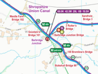 Shropshire Union Canal Map for Download
Rated 5 out of 5by Michael Moreau
Shropshire Union Canal Map for Download
Rated 5 out of 5by Michael Moreau -
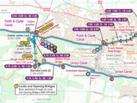 Forth & Clyde and Union Canals Map for Download
Rated 5 out of 5by Kim Henley
Forth & Clyde and Union Canals Map for Download
Rated 5 out of 5by Kim Henley -
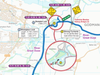 River Great Ouse and Tributaries Map for Download
Rated 4 out of 5by Clive Grounds
River Great Ouse and Tributaries Map for Download
Rated 4 out of 5by Clive Grounds
Recent Comments