
(click to enlarge).
Owners of my maps for individual waterways already have great maps.
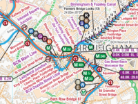
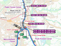
Even better are my England & Wales maps which cover the connected waterways – all those coloured on this map.
That’s more than 1,000 pages of maps in the Acrobat (pdf) version with the same maps joined into one large map you can scroll around and zoom in or out in the Memory‑Map (qct) version (with GPS tracking too).
Upgrade options
You can upgrade from any individual map(s) to the full England & Wales Maps.
The price and discount will depend on the time since your original purchase.
During the first 6 months
This will be the difference in price between the map(s) you purchased and the England & Wales map.
From 6 months to 4 years
From 6 months up to 4 years after purchase I give a gradually reducing discount to upgrade to the latest quarterly issue.
Just ask, and I’ll work out the quotation for you to give a great upgrade deal.
Asking for your upgrade

To obtain your upgraded map please email your request to info@waterwayroutes.co.uk with enough information for me to identify you original order(s). Ideally that will be the order number(s) but your name, address and postcode will usually be enough,
I will email you a no obligation quotation and a discount code to use if you wish to proceed. Please note this is a manual process and may take a few days, although it is often the same day.
 RSS Blog Feed
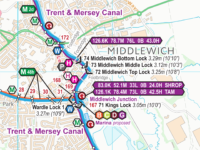

Recent Comments